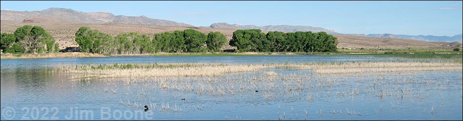
The Pahranagat Valley, located about 90 miles northeast of Las Vegas on Highway 93, has some great birding during winter and migration. This is a place to see waterfowl such as ducks, geese, and swans, plus cranes during migration and hawks during winter. The centerpiece of the area is the Pahranagat National Wildlife Refuge with a series of lakes of differing depths, miles of cottonwood trees, and extensive cattail marshes. Warblers and other passerines can be abundant in the trees around the ponds, and this can be a good place for watching dragonflies.
Pahranagat National Wildlife Refuge. Administered by the US Fish and Wildlife Service, this refuge covers 5,380 acres along a ten-mile stretch of Pahranagat Valley. The refuge includes a spring-fed riparian valley corridor with a series of broad, shallow lakes, brushy thickets, bulrush and cattail marshes, native grass meadows, and large cottonwood trees, all of which are surrounded by Mojave Desert scrub. These wetlands in the desert support a great variety of wildlife, and the refuge is an important wintering area and stop-over point for waterfowl and other migratory birds. This is also a good place to see dragonflies. Stop at the Visitor Center for information about visiting the Pahranagat Valley.
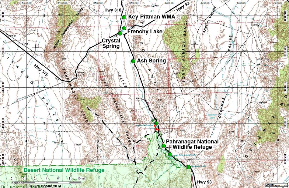
Ash Spring. A riparian area with water and trees in the Mojave Desert. The riparian area is fenced off with big "no trespassing" signs along the highway, but you can look over or through the fence to see the birds. This is not a destination, but rather one of several birding sites in the Pahranagat Valley to visit as a group or on the way to somewhere else.
Crystal Spring. A riparian area with warm springs, clear water, trees, shrubs, and grass in the desert. The spring is on private property, and people trashed the site, so now we see "no trespassing" everywhere. Bird the area from the highway right-of-way. This is not a destination, but rather one of several birding sites in the Pahranagat Valley to visit as a group or on the way to somewhere else.
Key Pittman Wildlife Management Area. Two small lakes just south of Hiko. Nesbitt, the northern lake, is broad and relatively deep with open water all year and an extensive marshy area at the northern end. Frenchy, the southern lake, is broad and shallow with open water only during wet years, but when it is wet, there is an extensive marsh around the entire lake.
Location
The Pahranagat Valley is located about 90 miles northeast of Las Vegas. To get there from Las Vegas, drive north on Highway I-15 for 21.7 miles to Highway 93 (Exit 64) (Table 1, Site 674). Exit the Interstate, turn left onto Highway 93, and drive north for about 70 miles to the town of Alamo (Site 675), which is in the heart of the Pahranagat Valley.
Services
Limited services in the Pahranagat Valley include gas, food, and lodging at Alamo, and a gas station with food at Ash Spring. Hiko has no services. There are eight campsites along the eastern shore of Upper Pahranagat Lake, and the Alamo Inn Motel is a low-end, but clean and reasonably priced place for a quick overnight.
Table 1. GPS Coordinates for Highway Locations (NAD27; UTM Zone 11S). Download Highway GPS Waypoints (*.gpx) file.
| Site # | Location | Latitude (°N) | Longitude (°W) | UTM Easting | UTM Northing | Elevation (feet) | Verified |
|---|---|---|---|---|---|---|---|
| 0444 | Highway 93 at Ash Spring | 37.4609 | 115.1930 | 659818 | 4147331 | 3,700 | Yes |
| 0674 | I-15 at Hwy 93 | 36.3809 | 114.8909 | 689188 | 4028063 | 2,232 | Yes |
| 0675 | Highway 93 at Alamo | 37.3646 | 115.1596 | 662974 | 4136909 | 3,452 | Yes |
Happy birding! All distances, elevations, and other facts are approximate.
![]() ; Last updated 240322
; Last updated 240322
| Birding Around Las Vegas | Southern Nevada Birds | Guide Service | Copyright, Conditions, Disclaimer | Home |