Birding Around Las Vegas, Outside the Las Vegas Valley
Death Valley National Park, the largest national park in the U.S., encompasses some 3.3 million acres of the Mojave Desert in eastern California. The land is diverse, with elevations ranging from -282 feet at Badwater (the lowest point in the Western Hemisphere) to 11,049 feet at the summit of Telescope Peak. In this arid land, great differences in elevation lead to great differences in topography and habitat. The overwhelming impression, however, is that this land is extremely hot and dry and unencumbered by the burden of dirt and vegetation. To the untutored eye, the entire area might even look barren, and while it is true that some areas appear lifeless, most areas support at least a few species of plants and animals.
There are, however, a few places where water from springs and irrigation supports lush oases (including species such as Date Palm trees; Honey Mesquite, Saltcedar, and Athel Tamarisk thickets; meadows; shrubs; and other vegetation) that stand in stark contrast to the surrounding desert. The vegetation in these few watered places provides food and cover for a great variety of birds and other wildlife. The birding in these places can be quite good because they concentrate the birds, especially during migration. While visiting, keep in mind that the oases are easily damaged, so be careful not to disturb the vegetation or the wildlife.
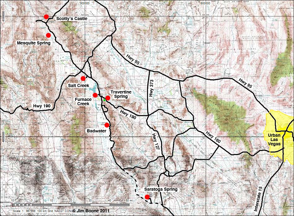
Badwater. Not the best place to bird, but a wild place to visit. Walk on the white expanse of nearly pure table salt, check the salty water for bugs, and watch the hills above the road for birds. Any bird that can live here is worth seeing!
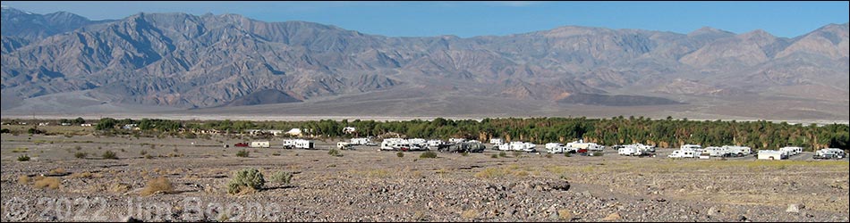
Furnace Creek. This developed area is a great place to bird. Look for birds in the trees and thickets around the campground and lodge areas, bird around the edges of the golf course, check the grove of date palms, and watch for hummingbird feeders and roadrunners in the residential area.
Mesquite Spring. A small spring that provides water for wildlife under a thicket of mesquite and cottonwood trees. This remote and scenic area can be a good place to look for birds and other wildlife that are attracted to the water and vegetation.
Salt Creek. A stream and saltmarsh with a 0.5-mile wooden boardwalk loop trail. Birds are attracted to the water and the vegetation. Watch for Salt Creek Pupfish, a species found nowhere else.
Saratoga Springs. A marsh with springs, ponds, and reeds, but no trees. In addition to birds, watch for Saratoga Springs pupfish (a subspecies found nowhere else) and several other endemics. The road is graded, but high-clearance vehicles are recommended.
Scotty's Castle. The grounds of the castle are landscaped with lawns, cottonwood trees, palm trees, running water, and shrubs that attract birds from all around, especially during migration.
Travertine Springs. Spring water supports a small stream, shrubs, and palms in Furnace Creek Canyon. Birds are attracted to the water and vegetation, but watch the highway traffic.
Overview
The park checklist includes 349 species of birds, a remarkable number considering the dry, seemingly barren environment. Most of the species are rare, casual, or accidental, but 20 species are listed as common during the heat of summer (granted, most of these occur in the mountains rather than on the valley floor). A surprising 105 species (including grebes, herons, waterfowl, rails, and shorebirds) have been recorded during all four seasons, although they are not considered to be residents. Fully 34 species have been recorded as common or uncommon during each season. Most of the species are migrants, and birding is best during spring (295 species recorded) and fall (313 species recorded), although 173 species have been recorded during summer and 165 during winter.
Death Valley generally is sunny, dry, and clear. Summers are unbelievably hot (temperatures commonly exceed 120 degrees) and dry, but the winters are mild with occasional storms. During summer, wear loose clothing that provides sun protection, a broad-brimmed hat, sunglasses, and sunscreen. Winter days might require a light jacket, but winter nights can be very cold. Always carry extra drinking water in your vehicle.
Limited services (gas, food, and camping) are available at Furnace Creek, Stovepipe Wells, and Panamint Springs. Lodging is available at Furnace Creek, Stovepipe Wells, and Panamint Springs, and there are a number of campgrounds scattered throughout the park. Furnace Creek and Stovepipe Wells have small stores with curios and basic camping supplies. This is wild and remote country; plan ahead and bring what you need.
This is a national park, so keep some regulations in mind. Collecting or disturbing animals, plants, rocks, or other natural, historical, or archeological features is prohibited. Don't feed or disturb wildlife, including coyotes, roadrunners, and ravens. All vehicles must remain on established roads. Keep pets confined or leashed (6 feet or shorter) at all times, and pets are allowed only in developed areas and along roads, not on trails. Don't litter.
Location
Death Valley National Park is located west-northwest of Las Vegas, about 2.5 hours from downtown.
The easiest way to get there from Las Vegas is to drive north on Highway 95 for about 90 miles to Highway 373 at Amargosa Valley (Table 1, Site 689). Turn left onto Highway 373 and drive south. At the California-Nevada state line, the road changes to Highway 127. Continue south on Highway 127 past the town of Death Valley Junction (Site 345). Turn right onto Highway 190 and drive west for about 30 miles to the Furnace Creek Visitor Center (Site 712). The Visitor Center provides a good introduction to the area.
Alternatively, a shorter route runs west out of Las Vegas on Highway 160. Drive west on Highway 160 for about 60 miles to Pahrump. In Pahrump, about 3 miles north of downtown, turn left onto Bell Vista Avenue (Site 719) and drive west for about 25 miles to Highway 127 at Death Valley Junction (note that the highway sign reads Bell Vista "Road"). Turn right onto Highway 127 and drive north for a few hundred yards to Highway 190 (Site 345), which is on the north side of town. Turn left onto Highway 190 and drive west for 30 miles to the Furnace Creek Visitor Center (Site 712). The Visitor Center provides a good introduction to the area.
Hours
The park is always open, but most of the birding sites are day-use only.
Fees
Entrance fees are $20 per private vehicle or $10.00 per person (on foot, horseback, or motorcycle) (Golden Eagle Pass and other passes accepted). The entrance fee is good for 7 days. Other fees apply to other situations; check the park website for details. Campground fees range from $12.00 to $18.00 per night, depending on services.
Specialties
Death Valley is good for finding desert species and migrants, but the species mix depends on the season, and during migration it depends on just who is moving through at the time. Review the park bird list (snatch a copy here) for the time of year that you are visiting to get ideas on what to expect.
For More Information
Visit the Death Valley website or visit the park. The Furnace Creek Visitor Center is open all year (8 AM to 6 PM) with exhibits on geology, climate, wildlife, natural history, human history, and the pioneer experience in the park.
A park map is available online.
Even more information is available by writing (Superintendent, Death Valley National Park, P.O. 579, Death Valley, CA, 92328-0579) or by calling the Visitor Center (760-786-3200).
Table 1. GPS Coordinates for Highway Locations (NAD27; UTM Zone 11S). Download Highway GPS Waypoints (*.gpx) file.
| Site # | Location | Latitude (°N) | Longitude (°W) | UTM Easting | UTM Northing | Elevation (feet) | Verified |
|---|---|---|---|---|---|---|---|
| 345 | Death Valley Junction | 36.3046 | 116.4143 | 552586 | 4017696 | 2,197 | Yes |
| 689 | Highway 95 at Highway 373 | 36.6439 | 116.3995 | 553676 | 4055332 | 2,660 | Yes |
| 712 | Death Valley Visitor Center | 36.4616 | 116.8657 | 512030 | 4034954 | -186 | Yes |
| 719 | Pahrump, Highway 160 at Bell Vista | 36.2638 | 116.0023 | 589622 | 4013467 | 2,647 | Yes |
Happy birding! All distances, elevations, and other facts are approximate.
![]() ; Last updated 240323
; Last updated 240323
| Birding Around Las Vegas | Southern Nevada Birds | Guide Service | Copyright, Conditions, Disclaimer | Home |