Datums are the mathematical foundation for the coordinate systems (Longitude and Latitude, UTM, State Plane, etc.) that we use to put grids on maps for referring to places. Three map datums, NAD27, NAD83, and WGS84, commonly are used. NAD83 and WGS84, are virtually identical (differ by inches around Las Vegas), but both are considerably different than NAD27, and this can cause problems when using GPS devices and printed maps.
If you don't care to understand the difference, just make sure that your GPS unit is set to match the map you are using. Around Las Vegas, hiking maps based on U.S. Geological Survey (USGS) topographical (topo) maps use the NAD27 system. If the maps are NAD27, and you set your GPS unit to NAD27, then everything will match when you are out hiking or when you give someone the coordinates of where you went.
If you want to fully understand datums, search the internet, perhaps starting with Wikipedia. The short version, however, is that NAD27 (North American Datum of 1927) was developed in about 1927, and the USGS used this system to put coordinates (grid lines) on their topo maps.
NAD27 was a good system, but we humans never leave well enough alone, and with modern satellites and highly accurate measurements of the earth, the WGS84 (World Geodetic System of 1984) datum was developed in about 1984. The new system is, well, a new and slightly improved version, and everyone likes to use newer and better things. Thus, if you start up a modern GPS unit, it is likely to be factory-set to WGS84. Some organizations, such as the Bureau of Land Management, have standardized on the NAD83 datum.
WGS84 and NAD 83 is fine systems, but they differ from the coordinate system printed on the USGS topo maps we use around Las Vegas. Below (Figure 1), a USGS topo map showing the original NAD27 grid lines (black). These are the actual lines printed on the original, bought-at-the-store USGS topographic maps. Overlain on this map is a WGS84 grid drawn in blue. The NAD83 grid is identical at this scale.
As can be seen (Figure 1), the blue and black grids don't match up. The offset is about 200 feet east-west, and about 600 feet north-south. Thus, if I'm using NAD27, I might say that I buried a pot of gold at 396000 E and 3991000 N (Point A in black). If you punch those coordinates into your handheld set at WGS84 and come looking for my pot of gold, you will think it is at Point B. You will never find my pot of gold because you'll be on the wrong side of the ridge.
Thus, if you hike around Las Vegas and use USGS topo maps, set your handheld GPS unit to NAD27 (or NAD27 CONUS). That way, your handheld unit will match the coordinate system drawn on the map.
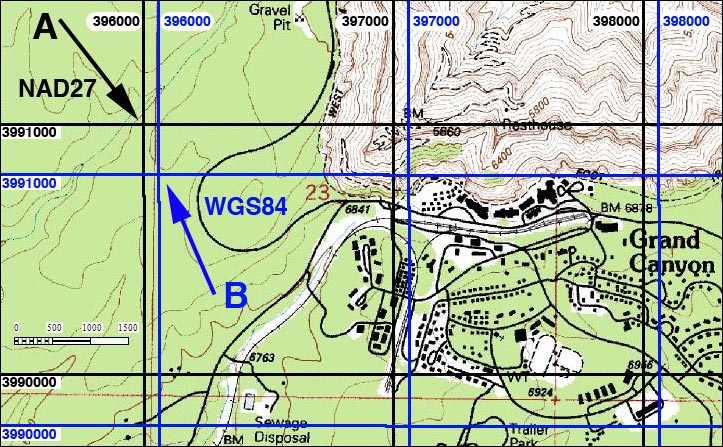
Figure 1. USGS Topo map showing black NAD27 and blue WGS84 grid lines (red lines are section lines)
Note: All distances, elevations, and other facts are approximate.
![]() ; Last updated 240323
; Last updated 240323
| Birding Around Las Vegas | Hiking Around Las Vegas | Glossary | Copyright, Conditions, Disclaimer | Home |