Backroads Around Las Vegas, Desert National Wildlife Refuge
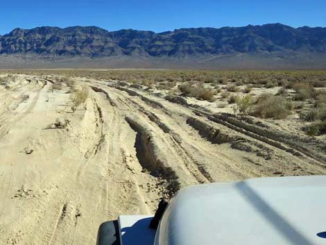 Dangerous condition: deep, heavy, playa dust at Desert Dry Lake |
Alamo Road Conditions From the DNWR website: Motorists on Alamo Road stand a good chance of getting stuck at Desert Dry Lake. The playa dirt has turned to powder (poof dirt). Conditions are hazardous. Given extreme heat and the slim chances of being found quickly, anyone whose vehicle gets stuck in that area is putting their life at risk. My recommendation: don't drive across the playa during summer when -- if you get stuck -- you die. Nov 2021. Road conditions are quite good, including crossing the playa where the poof-dust has stabilized after the fall rains. I'm sure this condition is temporary. Drivers: please send an email with current conditions. |
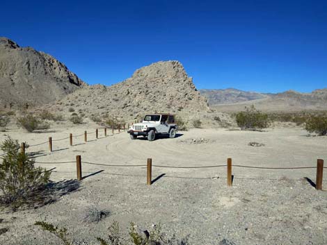
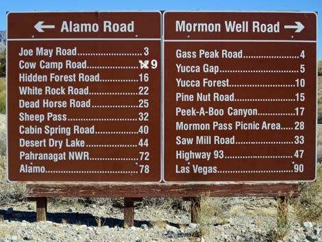 Sign at the intersection of Corn Creek Road, Alamo Road, and Mormon Well Road (view E) |
Overview Alamo Road connects Corn Creek Field Station in the south with the town of Alamo in the north. This bumpy, 70-mile dirt road runs along the west side of the Sheep Range until crossing over to the east side near the north end of the road. Perhaps not surprisingly, this road is called Old Corn Creek Road by people living in Alamo because, from the northern perspective, it was the road to Corn Creek. For several years, Alamo Road was closed to vehicles where it crosses Desert Dry Lake. However, the road is now open all the way from Highway 95 to Highway 93, but crossing the playa requires a 4WD-HC vehicle even when dry because of deep playa dust. Alamo Road North provides access to scenic, wild, and rugged country, including Desert Dry Lake, sand dunes (northern and southern), and historic ranching sites (corral and well). Link to map. |
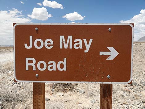 Joe May Road sign (view NNW from Alamo Road) Joe May Road sign (view NNW from Alamo Road) |
There are a number of primitive campsites along Alamo Road. Camping is unrestricted (except where signed "no camping"), so campers can stop anywhere, but be kind to the land and choose an existing campsite; don't drive off-road into the bushes to camp, and be sure to practice Leave No Trace techniques in these undeveloped campsites. Except for crossing the playa, which usually requires 4WD, the road generally is suitable for 2WD-HC vehicles, but it can also be rough, washed out, and muddy. Drivers should inquire at the visitor center about road conditions. This road runs into wild and remote country where one storm can change the road conditions to 4WD-only or worse. |
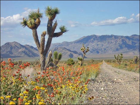 The wildflowers can be extraordinary |
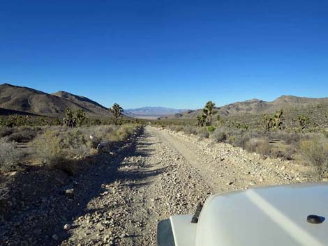
Alamo Road traverses typical middle-elevation Mojave Desert Scrub habitat with species such as Creosote Bush, White Bursage, Silver Cholla, and Joshua Trees. The road crosses many washes, so Cheesebush and Mojave Rabbitbrush can be common too. During spring, there can be many flowers along the road, including Bigelow's Monkeyflower, Desert Woollystar, Desert Marigold, Desert Globemallow, and Golden Evening-Primrose. Typical mammal species along Alamo Road North include Black-tailed Jackrabbit, Desert Cottontail, White-tailed Antelope Squirrel, Mule Deer, and even Desert Bighorn Sheep. At night, Desert Woodrats can be found in rocky areas, Merriam's Kangaroo Rats are widespread, and Desert Kangaroo Rats live in the sand dunes. On this dry landscape, birds are few and far between, but keep an eye out for Horned Larks, various desert sparrows, Common Raven, Loggerhead Shrikes, and Red-tailed Hawks. Lucky visitors might see a Golden Eagle soaring along limestone ridges. |
 White Dirt Campsite (view N) |
Watch Out Other than the standard warnings about being in the desert ... Alamo Road North generally is a good dirt road, but it runs out into wild and remote country. There are no services (no fuel) or developments of any kind. Cell phones in places, but don't count on it. Depending on carrier, cell service is possible from Corn Creek to Hidden Forest Road, from atop Sheep Pass, and even from North Dunes in the bottom of Desert Dry Lake Valley. Bring water and food, a spare tire, a shovel, tools, a tow rope, bailing wire, and anything else needed to survive a night or two stuck in the desert. Close in, the road is graded occasionally, but farther out the road has rocky spots and washouts that tend to sneak up in a way that could break an axle. The speed limit is 25 mph, and sticking to the speed limit will help prevent breaking axles on unseen rills or shredding tires on unexpected rocks in the road (friends experience). |
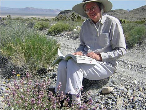 Flowers can be good out near Desert Dry Lake |
At the southeast edge of Desert Dry Lake, signs used to prohibit crossing the playa. The deeply rutted road and extremely deep playa dust, which is surprisingly difficult to drive through even in 4WD, resulted in too many people getting stuck and stranded on the playa in life-threatening summer conditions, so the refuge closed the section of road across the playa. The road is open now, but drive carefully on the playa and be prepared. While out, please respect the land and the other people out there, and try to Leave No Trace of your passage. Also, this road leads into remote country, so be sure to bring the 10 Essentials. This is a wildlife refuge, so pay extra attention to respecting the land and wildlife by driving carefully and staying on developed roadways. |
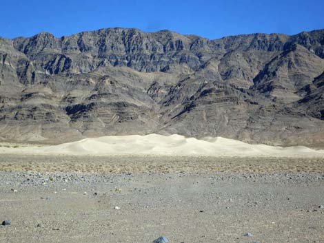 North Dunes (view NE from Alamo Road; zoom) |
Location Alamo Road is located on west side of Desert National Wildlife Refuge. As described here, Alamo Road starts at Corn Creek (Desert NWR Visitor Center near Highway 95) and runs northeast to Pahranagat NWR Visitor Center, exiting onto Highway 93. From town, top off the gas tank and drive out Highway 95 to Corn Creek Road, then turn right onto Corn Creek Field Station (DNWR Visitor Center). A few yards past (east of) the Visitor Center, Corn Creek Road ends at the T-intersection. Turn left onto Alamo Road. For the other end, drive north on Interstate 15 to Highway 93. Turn left onto Highway 93 and drive north to Pahranagat NWR. Follow signs to the Visitor Center, which is at the north end of Alamo Road (called Corn Creek Road in this area). |
 Corn Creek Rd at Alamo-Mormon Well roads intersection (view E) |
Alamo Road -- Corn Creek Road to Hidden Forest Road From Corn Creek Road, Alamo Road heads north leaving the desert oasis and passing mesquite-stabilized sand dunes on the left and the Sheep Range on the right. Eventually the road bends right and heads northeast for a total of 14.8 miles to Hidden Forest Road. This road usually is graded and suitable for carefully driven medium-clearance vehicles. After storms, however, the road can be badly wash from the many little washes that cross the road. Side roads have signs, but Alamo Road always continues straight ahead. This part of Alamo Road provides access to campsites, Joe May Canyon (with campsites), Cow Camp Road (with campsites), and some interesting desert birding in the mesquite thickets. |
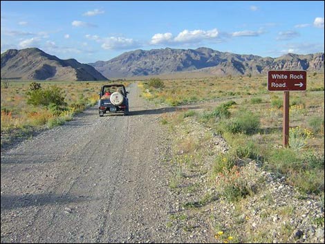 Alamo Road at White Rock Road (20.6 miles N of Corn Creek) |
Alamo Road -- Hidden Forest Road to Sheep Pass From Hidden Forest Road, Alamo Road heads north for 14.7 miles across a broad, flat valley before climbing into the East Desert Range and eventually reaching the saddle at Sheep Pass for a total of 29.6 miles from Corn Creek. This part of the road is graded from time to time and usually is suitable for high-clearance vehicles. After storms, however, the road can be badly wash from the many little washes that cross the road, and rills across the road can sneak up when unexpected and threaten to break the axles of unwary drivers. Side roads have signs, but Alamo Road always continues straight ahead. This part of Alamo Road provides access to campsites, White Rock Rd, White Dirt Camp, Deadhorse Road (with campsites), and grand scenery north and south from Sheep Pass. |
 Alamo Road with first views of Desert Dry Lake (view N) |
Alamo Road -- Sheep Pass to Cabin Canyon Road From Sheep Pass, Alamo Road heads north 8 miles to Desert Dry Lake and then east 2 miles to an intersection with Cabin Canyon Road for a total of 39.6 miles from Corn Creek. This part of the road is graded from time to time and usually is suitable for high-clearance vehicles. After storms, however, the road can be badly wash from the many little washes that cross the road, and rills across the road can sneak up when unexpected and threaten to break the axles of unwary drivers. Side roads have "do not enter" signs, but Alamo Road always continues straight ahead. This part of Alamo Road provides access to campsites and grand scenery out across Desert Dry Lake Valley. |
Dangerous condition: deep, heavy playa dust at Desert Dry Lake |
Alamo Road -- Cabin Canyon Road to across Desert Dry Lake Playa At the signed intersection with Cabin Canyon Road, Alamo Road turns left. From Cabin Canyon Road, Alamo Road heads north and east for 2.7 miles crossing the deep playa dust on the southeast corner of Desert Dry Lake for a total of 42.4 miles from Corn Creek. Because of the deep playa dust, this is the most technically difficult part of the road. This part of the road never is graded and usually is suitable only for high-clearance 4WD vehicles. After storms, the road can be wet and impassible. This part of Alamo Road provides access to a couple of historical cattle tanks, but in reality, it just provides a way to cross the playa. |
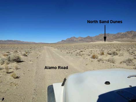 North Sand Dunes are getting closer (view N) |
Alamo Road -- Desert Dry Lake to Desert Sand Dunes From the north side of the playa crossing, Alamo Road heads north for 6.2 miles along the east edge of Desert Dry Lake to the parking area for a total of 48.5 miles from Corn Creek. The parking area is the trailhead for the walk to the north side of Desert Dry Lake Dunes. This part of the road is graded from time to time and usually is suitable for high-clearance vehicles. After storms, however, the road can be washed and quite muddy from the many little washes that cross the road. One side road is signed, but Alamo Road always continues "straight" ahead. This part of Alamo Road provides access to campsites, an historical mill site, an historical corral site, and Desert Sand Dunes. |
 Alamo Road approaching Pahranagat NWR (view NE) |
Alamo Road -- Sand Dunes to Highway 93 From Desert Sand Dunes, Alamo Road heads north for 11.6 miles before bending northeast (3 miles) to pass through gaps in the East Pahranagat Range. The road descends 4.3 miles to the west edge of Pahranagat Valley. Following north 1.8 miles along the edge of the marsh, the road reaches Pahranagat NWR Visitor Center and shortly beyond reaches the pavement at Highway 93, for a total of 69.8 miles from Corn Creek. This part of the road is graded from time to time and usually is suitable for high-clearance vehicles. After storms, however, the road can be washed at any of the many places where the road runs it or crosses washes. Side roads have signs, but Alamo Road always is the main road (whether bending left or right at intersections). This part of Alamo Road provides access to campsites, grand scenery, and the pavement at Highway 93. |
Table 1. Highway Distances Based on GPS Data (NAD27; UTM Zone 11S). Download Highway GPS Waypoints (*.gpx) file.
| Wpt. | Location | Latitude (N) | Longitude (W) | Elevation (ft) | Point-to-Point Distance (mi) | Cumulative Distance (mi) |
|---|---|---|---|---|---|---|
| 1295 | Corn Creek Rd at Alamo-Mormon Rd | 647311 | 4033593 | 2,933 | 0.00 | 00.00 |
| 1517 | Alamo Rd at Corn Creek Campsite | 647212 | 4034068 | 2,969 | 0.30 | 00.30 |
| 0780 | Alamo Rd at Joe May Canyon Rd | 646366 | 4038614 | 3,240 | 2.88 | 03.18 |
| 1336 | Alamo Rd at Wellhead Camp Rd | 643035 | 4044499 | 3,411 | 4.35 | 07.53 |
| 0992 | Alamo Rd at Cow Camp Rd | 643589 | 4046289 | 3,547 | 1.16 | 08.69 |
| 0882 | Alamo Rd at Hidden Forest Rd | 647279 | 4055442 | 4,490 | 6.15 | 14.84 |
| 1226 | Alamo Rd at Pine Canyon Rd | 647637 | 4057079 | 4,492 | 1.04 | 15.88 |
| 1227 | Alamo Rd at Slate Mine Rd | 648121 | 4058626 | 4,426 | 1.01 | 16.89 |
| 1228 | Alamo Rd at White Sage Road | 650049 | 4062820 | 4,249 | 2.87 | 19.76 |
| 0455 | Alamo Rd at White Rock Rd | 650590 | 4064035 | 4,230 | 0.83 | 20.59 |
| 0738 | Alamo Rd at White Dirt Camp Rd | 651421 | 4066033 | 4,264 | 1.35 | 21.94 |
| 0552 | Alamo Rd at Deadhorse Rd | 651727 | 4068747 | 4,272 | 1.70 | 23.64 |
| 0553 | Alamo Rd at Sheep Pass | 651931 | 4077996 | 4,981 | 5.92 | 29.56 |
| 0554 | Alamo Rd at Desert Dry Lake Rd | 652465 | 4087819 | 3,477 | 6.84 | 36.40 |
| 0593 | Alamo Rd at Dry Lake Camp Rd | 655369 | 4088573 | 3,283 | 2.14 | 38.54 |
| 0098 | Alamo Rd at Cabin Spr Rd | 656773 | 4087799 | 3,235 | 1.08 | 39.62 |
| 0489 | Alamo Rd at South Closure | 657093 | 4088514 | 3,231 | 0.49 | 40.11 |
| 0543 | South Dunes Trailhead | 659772 | 4089937 | 3,210 | 2.21 | 42.32 |
| 1789 | Alamo Road North at Dry Lake Well Road | 660691 | 4090867 | 3,233 | 0.82 | 43.14 |
| 1788 | Alamo Road at Dry Lake Corral Road | 660570 | 4096188 | 3,206 | 3.50 | 46.64 |
| 0736 | Alamo Road at North-Dune Road South | 660491 | 4096942 | 3,238 | 0.47 | 47.11 |
| 0735 | Alamo Road at North-Dune Road North | 659840 | 4098880 | 3,255 | 1.43 | 48.54 |
| 0542 | Alamo Rd Jct | 659672 | 4106391 | 3,653 | 4.73 | 53.27 |
| 0493 | Alamo Rd Jct | 661202 | 4115981 | 4,123 | 6.92 | 60.19 |
| 1541 | Alamo Rd N at Service Road | 662562 | 4115851 | 4,006 | 1.03 | 61.22 |
| 1878 | Alamo Rd at Old DNWR Boundary | 664312 | 4118684 | 3,924 | 2.32 | 63.54 |
| 0492 | Pahranagat Rd at Alamo Rd | 667067 | 4123522 | 3,282 | 4.00 | 67.54 |
| 0943 | Pahranagat Rd at HQ Rd | 666681 | 4126297 | 3,322 | 1.82 | 69.36 |
| 0486 | Hwy 93 at Pahranagat VC Rd | 667132 | 4126732 | 3,335 | 0.44 | 69.80 |
Happy Hiking! All distances, elevations, and other facts are approximate.
![]() ; Last updated 240324
; Last updated 240324
| Backroads Around DNWR | Hiking Around Las Vegas | Glossary | Copyright, Conditions, Disclaimer | Home |