Hiking Around Las Vegas, Gold Butte
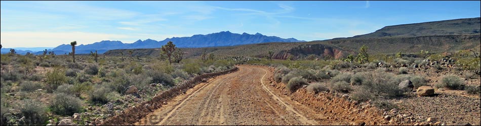
 Scenery along Whitney Pass Road: Virgin Mountains |
Overview Pakoon Spring Loop is a 41-mile driving loop that, as described here, starts and ends at Whitney Pocket. From the start (Gold Butte Road-southbound at Whitney Pass Road), the loop runs east on Whitney Pass Road to Pakoon Road over on the other side of the Virgin Mountains. Pakoon Road is followed south into Arizona, past Pakoon Spring, and down to St. Thomas Gap Road, which is followed back west into Nevada to connect with Gold Butte Road. Returning over Gold Butte Road-northbound, the loop is closed upon return to Whitney Pocket. This road makes for a nice day out on seasonally maintained roads in some wild and remote country. Link to map. |
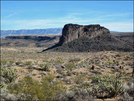 Scenery along Pakoon Road: the core of an extinct volcano |
Watch Out Other than the standard warnings about driving in the desert, ... this loop uses some of the main, maintained dirt roads in the region, and as such, is relatively straight forward with long straight sections, gentle curves, and generally a smooth surface; however, roads wash out, so always be careful at wash crossing and use your good judgment regarding sandy sections. In particular, the lower end of St. Thomas Gap Road can be sandy, and driving in these areas always is safer in a 4WD vehicle. This is a wild and remote area without services of any kind (no restrooms, no water, no gas, no food). Bring what you need to survive. Be prepared and be self-reliant. Someone will find you eventually if you stay on a main road, but be prepared to survive alone for a day or two. Cell phones don't work. While visiting the area, please respect the land and the other people out there, and try to Leave No Trace of your passage. Also, this area is remote, so be sure to bring the 10 Essentials. |
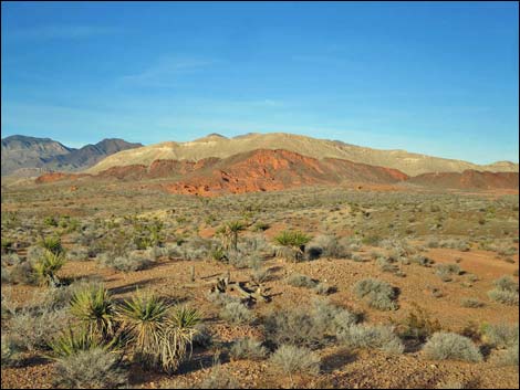 Scenery along St. Thomas Gap Road: Mud Hills |
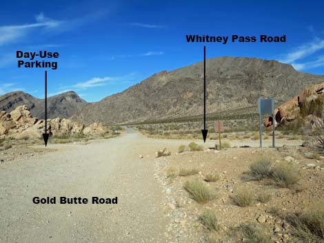
Getting to the Roadhead Pakoon Spring Loop is located out in Gold Butte, Nevada, and Grand Canyon - Parashant National Monument, Arizona. Starting from Whitney Pocket, this adventure starts about 1-1/2 hours east of Las Vegas, in the wild, remote, and scenic Gold Butte south of the town of Mesquite. From Las Vegas, drive out to Gold Butte. Drive south 21 miles on the paved Gold Butte Road to Whitney Pocket at the end of the pavement. About 100 yards past the pavement, Whitney Pass Road forks to the left, and here starts the loop. |
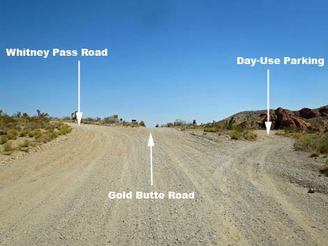 Gold Butte Road at Whitney Pass Road (Whitney Pocket; view S) |
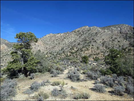
DRIVING THE LOOP Leg 1: Whitney Pass Road From Gold Butte Road-southbound at Whitney Pass Road (Table 1, Site 0462), the loop runs east on Whitney Pass Road past the red-and-white sandstone crags and out across the open desert climbing at a fair grade towards the Virgin Mountains. After bending hard to the left around Quail Point, the road climbs more steeply into the mountains. The road passes an historic stone watering trough in the trees, climbs over Whitney Pass, and then descends to a major fork (Site 1659). Here, Whitney Pass Road ends and Pakoon Road stays to the right. The left can be used to climb over Lime Kiln Pass and drop into Mesquite. For details of this section, see Whitney Pass Road. |
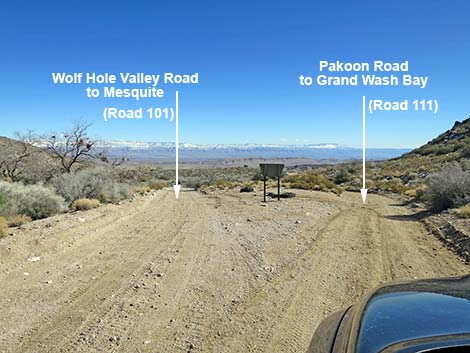 Whitney Pass Road at Pakoon Road (view SE) |
Leg 2: Pakoon Road Staying right onto Pakoon Road, the road passes through the Nay Ranch (please stay on the roadway and respect private property), crosses into Arizona, and descends into the scenic Pakoon Valley. After wrapping north around the toe of a ridge, the road generally runs south following washes and running on high ground with grand views. The road passes historic corrals, Pakoon Spring, Burro Spring, and several washes. Pakoon Spring would be a good place to walk in past the gate and eat lunch under the trees. Continuing south, the road ends at an intersection with St. Thomas Gap Road. After flash floods, the road can wash out, so always exercise good judgment in these areas, and there is an unexpectedly tight curve just past Burro Spring. For details of this section, see Pakoon Road. |
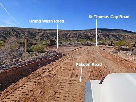 Pakoon Rd at St. Thomas Gap Rd (view W) |
Leg 3: St. Thomas Gap Road Staying right onto St. Thomas Gap Road, the road runs up Black Wash, dipping in and out of the sandy wash several times. This part of the road can become quite sandy, so use good judgment if driving a 2WD vehicle. After about 2 miles, the road climbs out of Black Wash to run across firm, high desert country with grand views all around. The mountains to the north are the Virgin Range, so the view provides an idea of how far one is away from "home." St. Thomas Gap Road bends west and runs over low hills to end near the base of Tramp Ridge when the road intersects Gold Butte Road. For details of this section, see St. Thomas Gap Road. |
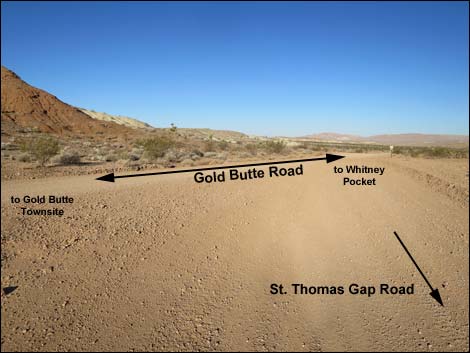 St. Thomas Rd at Gold Butte Road (view NW) |
Leg 4: Gold Butte Road Staying right onto Gold Butte Road-northbound, the road traverses grand scenery with the Mud Hills on the right and views down Mud Wash Valley on the left. Staying straight on the main road, drivers pass a signed intersection with Mud Wash Road (turnoff to Devils Throat; Site 0807) and a signed intersection with Mud Wash North Road (Site 1649). The road becomes very rough with a cobblestone-like surface before finally returning to Whitney Pocket. For details of this section, see Gold Butte Road-northbound. |
 |
Gold Butte Road returning to Whitney Pass Road (Whitney Pocket; view N) |
Table 1. Highway Coordinates Based on GPS Data (NAD27; UTM Zone 11S). Download Highway GPS Waypoints (*.gpx) file.
| Wpt. | Location | Latitude (N) | Longitude (W) | Elevation (ft) | Point-to-Point Distance (mi) | Cumulative Distance (mi) |
|---|---|---|---|---|---|---|
| 0462 | Gold Butte Rd at Whitney Pocket | 36.52327 | 114.13920 | 3,013 | 00.00 | 00.00 |
| 1659 | Arizona Rd at Pakoon Rd | 36.52592 | 114.05843 | 4,453 | 05.10 | 05.10 |
| 1757 | Pakoon Rd at Pakoon Spring Rd | 36.41991 | 113.96447 | 2,359 | 10.70 | 15.80 |
| 1758 | Pakoon Rd at Side Road | 36.38635 | 113.95409 | 2,063 | 02.66 | 18.46 |
| 1759 | Pakoon Rd at St. Thomas Gap Rd | 36.34606 | 114.00660 | 1,827 | 04.55 | 23.01 |
| 1760 | St. Thomas Gap Rd at State Line | 36.38133 | 114.04542 | 2,206 | 03.54 | 26.55 |
| 0796 | St Thomas Gap Rd at Gold Butte Rd | 36.41359 | 114.12277 | 2,427 | 05.46 | 32.01 |
| 0807 | Gold Butte Rd at Mud Wash Rd | 36.43258 | 114.14300 | 2,244 | 01.78 | 33.79 |
| 1649 | Gold Butte Rd at Mud Wash North Rd | 36.47546 | 114.16339 | 2,388 | 03.33 | 37.12 |
| 0462 | Gold Butte Rd at Whitney Pocket | 36.52327 | 114.13920 | 3,013 | 03.91 | 41.03 |
Happy Hiking! All distances, elevations, and other facts are approximate.
![]() ; Last updated 240326
; Last updated 240326
| Hiking Around Gold Butte | Hiking Around Las Vegas | Glossary | Copyright, Conditions, Disclaimer | Home |