Hiking Around Las Vegas, Mount Charleston Area, Lee Canyon
The Mud Springs Loop Trail is a 15.5-mile loop that starts from the Sawmill Trailhead along Lee Canyon Road and runs out to the northwest. I've not hiked this trail, but the map is mostly accurate except in the area around Mud Springs and Waypoint 24. Waypoints 20 through 30 were chosen for strategic directions at places where the trail is visible on aerial photos.
Hikers should not expect to find water at Mud Spring, but those with 4WD vehicles could cache water near Waypoint 26 or 27.
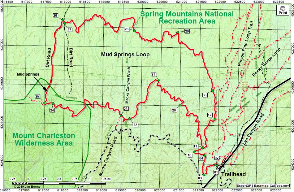
Note: Map based on USGS 7.5-minute topo map, which may have red grid lines and various numbers. North is at the top. Grid is UTM NAD27 CONUS. Roads are black (solid = paved; dashed = unpaved; width implies quality). Trails and routes are red (solid = main; dashed = adjacent or alternate). Wilderness Areas (boundaries solid green, fill light green) based on BLM data. National Forest areas (boundaries dashed brown, fill light green) based on USFS data. Download waypoint coordinates from route description page.
Table 1. Hiking Coordinates and Distances based on GPS Data (NAD27; UTM Zone 11S). Download hiking GPS waypoints (*.gpx) file.
| Wpt. | Location | UTM Easting | UTM Northing | Elevation (ft) | Point-to-Point Distance (mi) | Cumulative Distance (mi) |
|---|---|---|---|---|---|---|
| 01 | Sawmill Trailhead | 621985 | 4023976 | 7,591 | 0.00 | 00.00 |
| 02 | Trail Junction | 621948 | 4023991 | 7,589 | 0.03 | 00.03 |
| 03 | South-most Point | 621644 | 4023727 | 7,688 | 0.33 | 00.36 |
| 04 | Trail Junction | 621664 | 4024228 | 7,667 | 0.35 | 00.71 |
| 10 | Turn out of Wash | 621393 | 4024316 | 7,757 | 0.21 | 00.92 |
| 11 | Trail Junction | 621609 | 4024436 | 7,829 | 0.16 | 01.08 |
| 20 | Bend | 621008 | 4025517 | 7,395 | 1.26 | 02.34 |
| 21 | Bend | 620441 | 4026150 | 7,316 | 1.00 | 03.34 |
| 22 | Bend | 619708 | 4025152 | 7,710 | 0.94 | 04.28 |
| 23 | Trail Junction | 619490 | 4025229 | 7,595 | 0.25 | 04.53 |
| 24 | Saddle | 617721 | 4025516 | 7,700 | 2.03 | 06.56 |
| 25 | Trail Junction | 617490 | 4025528 | 7,651 | 0.17 | 06.73 |
| 26 | Fork in Road | 617943 | 4027683 | 6,932 | 1.47 | 08.20 |
| 27 | Depart Road | 617990 | 4027590 | 6,955 | 0.08 | 08.28 |
| 28 | Macks Canyon Wash | 619798 | 4027420 | 6,962 | 2.21 | 10.49 |
| 29 | Ridgeline | 620921 | 4027396 | 6,913 | 1.23 | 11.72 |
| 30 | Trail Junction | 621837 | 4025900 | 7,419 | 1.50 | 13.22 |
| 12 | Trail Junction | 621916 | 4025168 | 7,654 | 0.49 | 13.71 |
| 11 | Trail Junction | 621609 | 4024436 | 7,829 | 0.65 | 14.36 |
| 10 | Turn out of Wash | 621393 | 4024316 | 7,757 | 0.16 | 14.52 |
| 04 | Trail Junction | 621664 | 4024228 | 7,667 | 0.21 | 14.73 |
| 03 | South-most Point | 621644 | 4023727 | 7,688 | 0.35 | 15.08 |
| 02 | Trail Junction | 621948 | 4023991 | 7,589 | 0.34 | 15.42 |
| 01 | Sawmill Trailhead | 621985 | 4023976 | 7,591 | 0.03 | 15.45 |
Happy Hiking! All distances, elevations, and other facts are approximate.
![]() ; Last updated 190526
; Last updated 190526
| Sawmill Area Trails | Hiking Around Mt. Charleston | Glossary | Copyright, Conditions, Disclaimer | Home |