Hiking Around Las Vegas, Red Rock Canyon National Conservation Area

 Wash beyond Calico Tanks turnoff (view NE) |
Overview This stout hike starts at Sandstone Quarry (4,370 ft) and heads east into the La Madre Mountain Wilderness Area. Following washes, ridges, and very steep hillsides for 2-3/4 miles, this route leads to the summit of Gray Cap Peak (5,425 ft), a mountain that gets its name from a small cap of gray limestone that sits atop a ridge of red and white sandstone. The route includes several 3rd-class pour-overs that can be bypassed, but the bypasses are not much easier or safer, and there are several twists and turns that make route finding a challenge. The challenge of the climb and views from the top make this route well worth the effort. Link to map or elevation profile. |
 Hiker turning into unexpected slot canyon (view E) |
Watch Out Other than the standard warnings about hiking in the desert, ...this is a very strenuous hike that requires 2nd-class and 3rd-class scrambling to get past pour-overs. Falls from many places along the route would result in serious injuries. This route is not appropriate for young children. While hiking, please respect the land and the other people out there, and try to Leave No Trace of your passage. Also, even though this is a short hike, it is a remote area, so be sure to bring what you need of the 10 Essentials. This route runs up into designated Wilderness, so please pay particular attention to respecting the land. |
 Hikers in unexpected slot canyon (view SE) |
Getting to the Trailhead This hike is located along the Scenic Loop Road in Red Rock Canyon National Conservation Area, about 45 minutes west of Las Vegas. Drive out to Red Rocks, pay the entrance fee, and drive up the Scenic Loop Road for about 3 miles to the Sandstone Quarry Trailhead. Park here; this is the trailhead. |
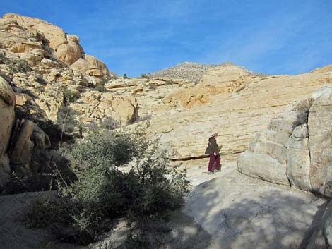
 W Fork Gateway Canyon (view SE; 1st summit view) |
The Hike From the trailhead (Table 2, Waypoint 01), the Sandstone Quarry Trail runs north into the Sandstone Quarry historic area. The trail passes to the west of the actual quarry, passes a trail sign (Wpt. 02), drops into a big wash, and continues northward. About 2 minutes beyond the historic area, the trail forks (Wpt. 03). The Turtlehead Peak Trail turns left (north), while the Calico Tanks Trail continues straight (east). Continue on the Calico Tanks Trail. The Calico Tanks Trail bends to the east following along the north side of the large wash and shortly arrives at an agave roasting pit. An information sign explains how prehistoric humans used the area (think about it -- people just like you and me lived here). |
 N Fork Gateway Canyon (view NW) |
The trail then drops back into the wash and follows it into a canyon with lots of canyon live oak trees. When the Calico Tanks Trail bends to the southeast and starts up a side canyon into the heart of the Calico Hills (Wpt. 04), the Gray Cap route continues northeast following the main wash. At a fork in the canyon (Wpt. 05), the Gray Cap route continues east, then generally trends northeast following the wash. There is an unexpected slot canyon in the sandstone and places where hikers can walk in the wash or walk on the sandstone slickrock above the wash. The route eventually climbs onto and crosses a low ridge (Wpt. 06) at the interface of the sandstone Calico Hills to the south and gray limestone dirt to the north. Continuing east, a use-trail runs southeast across the dirt hillside and eventually starts down into the West Fork of Gateway Canyon. |
 Pour-over #1 (view NW) |
As the use-trail runs down the hillside, the canyon bends to the northeast, and near the bend, a use-trail forks off to the south (Wpt. 07) heading for Ash Spring and Calico Basin, a route that can be used to circumnavigate the Calico Hills. The use-trail switches to the south side of the canyon, eventually drops into the bottom of the wash (Wpt. 08), and continues downhill to the confluence of the North and West Forks of Gateway Canyon (Wpt. 09). Turning up the North Fork of Gateway Canyon, the route runs up into the narrow limestone canyon until sandstone is reached again. Passing through this canyon, however, is not a trivial matter as there are many boulders to get around and three major pour-overs (Wpts. 10, 11, 12) that require 2nd- and 3rd-class scrambling to pass. The scramble-ups can be bypassed, but the routes are more obvious on the way down. |
 Pour-over #2 (view N) |
Eventually the canyon opens, the angle lessens, and the wash runs up against sandstone again (Wpt. 13). This is where the faint-of-heart might want to stop. When the route passes off the limestone rock and gets back onto red sandstone, it turns out of the wash and runs straight up the steep hillside to the east aiming for a Utah Juniper tree growing on the skyline (Wpt. 14; see photos [below] of the tree on skyline). Many paths lead up the hillside, but all are steep. You probably will pick a different route on the way down because surely there is something better than the route you took up. From the juniper on the skyline, the route continues east for a few yards to an overlook above a huge tinaja (Wpt. 15). It is hard to imagine how such a feature developed, let alone how it fills with and holds water. |
 Grapevine Canyon below steep hillside (view NE) |
The tinaja is passed atop a sandstone fin that forms the northeast wall of the tinaja, then the route curves to the southeast to gain the ridgeline (Wpt. 16) beyond the tinaja. Crossing the ridgeline to the south side of the ridge, a broad ledge system angles down and southeast. Following the ledges, the route drops into a large bowl (Wpt. 17) where water collects, and the ground can be muddy. From the bowl, the route climbs a second steep hillside heading up and northeast towards what appears from below to be a saddle. Winding among small cliffs and large boulders, the route crosses through the "saddle" and continues up and east towards the ridgeline. |
 Many routes lead to juniper on skyline (view NE) |
Eventually, a use-trail becomes apparent, and this is followed upward on white sandstone until gray limestone is reached (Wpt. 18). The gray is the "gray" of Gray Cap, and shortly thereafter the summit (Wpt. 19) is reached. The summit is a great place to sit, relax, and enjoy good company and the scenery. To the west is Turtlehead Peak and the Wilson "Red Rocks" Cliffs in the distance. To the north the towering limestone of La Madre Mountain looms overhead. To the east is Brownstone Canyon, the toe of the La Madre Range, and Las Vegas in the distance. Even farther east is Lake Mead and mountains in Arizona. To the south are Calico Basin, Blue Diamond Hill, and mountains off into the distance. When ready to leave, be sure to sign the summit register, and then pick your way carefully back down the cliffs and pour-overs following your footprints back to the trailhead. |
 Hikers on steep hillside below juniper on skyline |
 Tinaja and route |
 Hikers on ledges |
 Hikers departing the bowl |
 Hikers approaching the summit |
 Friends on the summit |
Table 2. Hiking Coordinates Based on GPS Data (NAD27; UTM Zone 11S). Download Hiking GPS waypoints (*.gpx) file.
| Wpt. | Location | Easting | Northing | Elevation (ft) | Point-to-Point Distance (mi) | Cumulative Distance (mi) | Verified |
|---|---|---|---|---|---|---|---|
| 01 | Trailhead | 639469 | 4002874 | 4,370 | 0.00 | 0.00 | GPS |
| 02 | Quarry | 639461 | 4003003 | 4,311 | 0.09 | 0.09 | GPS |
| 03 | Turtlehead Peak Trail | 639419 | 4003162 | 4,339 | 0.11 | 0.20 | GPS |
| 04 | Calico Tanks Trail | 639635 | 4003352 | 4,369 | 0.19 | 0.39 | GPS |
| 05 | Fork in Canyon | 639717 | 4003424 | 4,391 | 0.08 | 0.47 | GPS |
| 06 | Highpoint | 639958 | 4003568 | 4,490 | 0.23 | 0.70 | GPS |
| 07 | Ash Spring Route | 640409 | 4003454 | 4,483 | 0.31 | 1.01 | GPS |
| 08 | Trail into Wash | 640541 | 4003659 | 4,414 | 0.15 | 1.16 | GPS |
| 09 | Gateway Canyon | 640751 | 4003953 | 4,224 | 0.25 | 1.41 | GPS |
| 10 | Pour-Over #1 | 640624 | 4004298 | 4,401 | 0.27 | 1.68 | GPS |
| 11 | Pour-Over #2 | 640516 | 4004469 | 4,531 | 0.15 | 1.83 | GPS |
| 12 | Pour-Over #3 | 640518 | 4004560 | 4,613 | 0.08 | 1.91 | GPS |
| 13 | Leave Wash | 640678 | 4004702 | 4,731 | 0.15 | 2.06 | GPS |
| 14 | Juniper on Skyline | 640817 | 4004791 | 5,009 | 0.15 | 2.21 | GPS |
| 15 | Tinaja | 640882 | 4004791 | 5,024 | 0.03 | 2.24 | GPS |
| 16 | Ridge | 641010 | 4004745 | 5,129 | 0.13 | 2.37 | GPS |
| 17 | Bowl | 641175 | 4004714 | 5,036 | 0.12 | 2.49 | GPS |
| 18 | Edge of Gray | 641424 | 4004762 | 5,371 | 0.22 | 2.71 | GPS |
| 19 | Summit | 641484 | 4004728 | 5,425 | 0.05 | 2.76 | GPS |
Happy Hiking! All distances, elevations, and other facts are approximate.
![]() ; Last updated 240330
; Last updated 240330
| Hiking Around Red Rocks | Hiking Around Las Vegas | Glossary | Copyright, Conditions, Disclaimer | Home |