Hiking Around Las Vegas, Red Rock Canyon National Conservation Area
 Trailhead (view NW) |
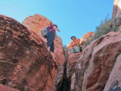
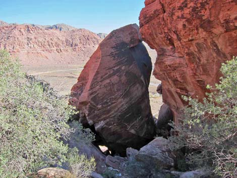
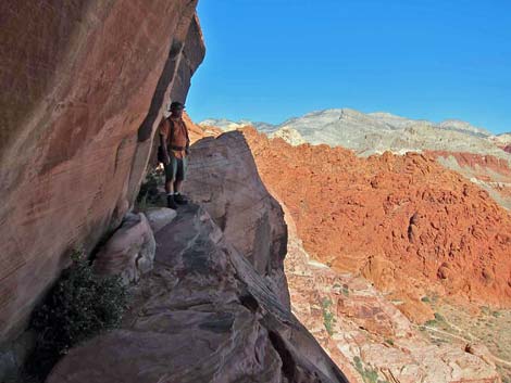
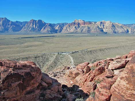
Overview I have a report that, due to rockfall, this is now a 4th or minimal 5th class route with exposure. This route is a 3rd-class scramble through some interesting rock features to an enormous crevice (Slab Rift) and a lookout at the top of the Calico Hills. One side of the crevice is the crest of the Calico Hills, and the other is perhaps the largest free-standing boulder in Red Rock Canyon. After clambering through the rift, hikers are rewarded with a narrow, shady ledge very high above the ground that provides grand views out across Calico Basin and a nice place for lunch. On cold days, hikers might prefer a sunny overlook surveying the Scenic Loop Road and all of the Red Rock (Wilson) Cliffs. The route takes a short detour to visit petroglyphs. Link to map. |
 |
Watch Out Other than the standard warnings about hiking in the desert, ... this hike is a 3rd-class (maybe harder) scramble with all of the usual scrambling hazards (e.g., falls from high places, loose rocks), but nothing unusual. While the scrambling is only 3rd-class, falls from many places would ensure sudden death, and it would be easy to find routes through the rocks more difficult than 3rd-class. Also, while shrubs might provide handy handholds, branches tend to break, so avoid hanging on the bushes. While hiking, please respect the land and the other people out there, and try to Leave No Trace of your passage. Also, even though this route is short, be sure to bring what you need of the 10 Essentials. |
 Hikers approaching Cannibal Crag (view NW) |
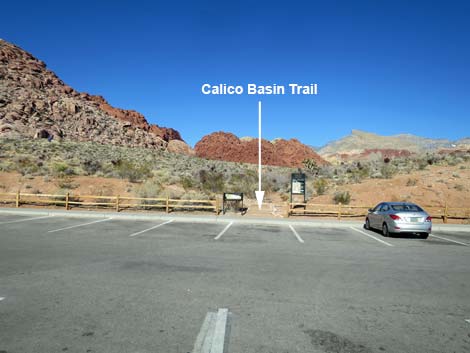
Getting to the Trailhead This hike is located in Red Rock Canyon National Conservation Area, about 25 minutes from town, but not in the Scenic Loop Road fee area. Drive out West Charleston Blvd, turn right onto Calico Basin Road, and then drive into the Red Spring Trailhead. Park here; this is the trailhead. The parking area closes at sunset, so don't stay too late and get locked in. |
 Northeast corner of Cannibal Crag (view NW) |
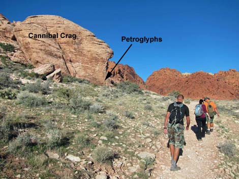
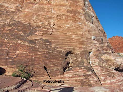
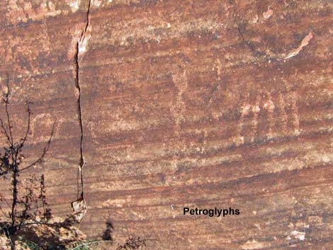
The Hike From the trailhead (Table 2, Waypoint 01), the route starts on a trail by the restrooms on the northwest side of the parking lot. The trail heads northwest towards a rock outcrop with petroglyphs, and the rock outcrop, known to rock climbers as Cannibal Crag, can be seen from the trailhead. The trail runs northwest, merges with a wider trail (Wpt. 02), and continues to the base of Cannibal Crag (Wpt. 03). The petroglyphs are on the northeast corner of the crag. The rock art here is not extensive, but it is always interesting to contemplate the lives of people who made this area home so long ago. More rock art can be seen along the Red Spring Boardwalk. |
 Northeast corner of Cannibal Crag (close-up; view NW) |
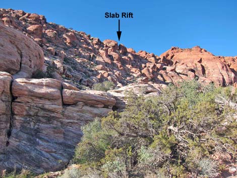
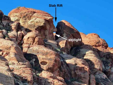
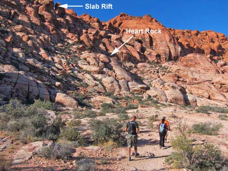
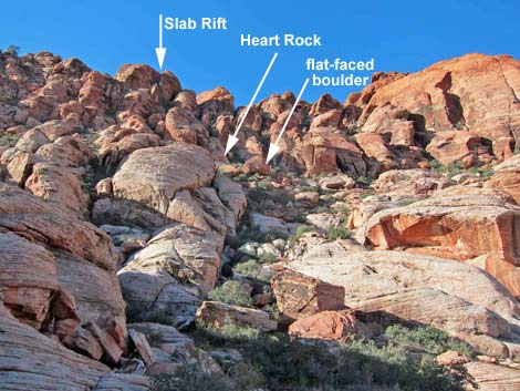
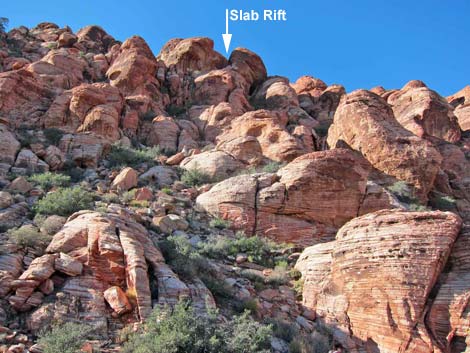
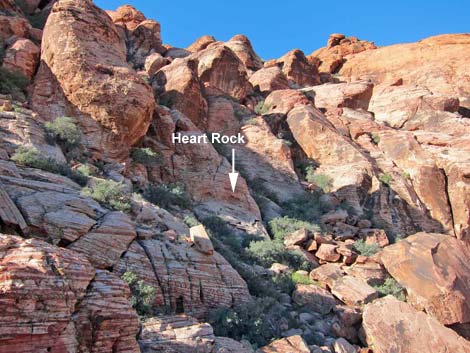
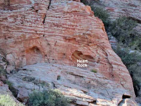
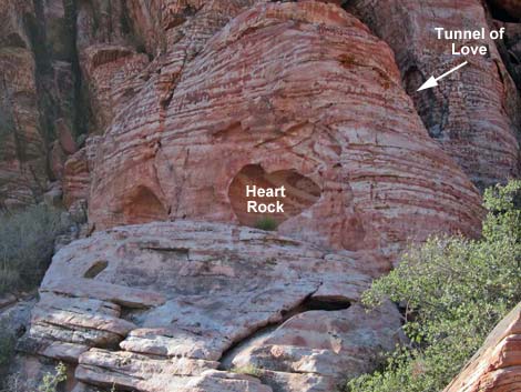
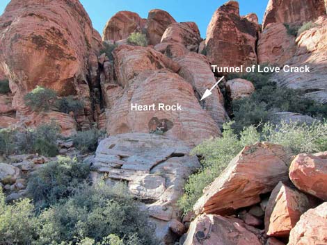
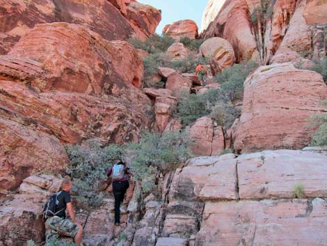
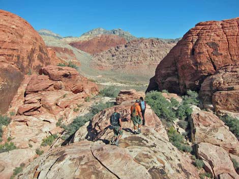
From Cannibal Crag (Wpt. 03), the route follows the wide trail northwest along the base of the Calico Hills. After only 100 yards, Slab Rift can be seen to the southwest atop of the Calico Hills. Look for what appears to be an arch (or perhaps just sky through a hole in the rocks) on the skyline, a bit left of the largest slab of rock (Riding Hood Wall) on the skyline. Continuing on the wide trail about 300 yards past Cannibal Crag, the trail arrives at a point (Wpt. 04) directly below Slab Rift. In this vicinity, it becomes necessary to locate Heart Rock (Wpt. 05), which is up the hillside below Slab Rift and the key to finding the rest of the rock features along the route. Heart Rock is a relatively small, heart-shaped alcove, so it is hard to see from below, but a large, flat-faced boulder (photos) lies just below Heart Rock. Heart Rock is on the base of the headwall, and the flat-faced boulder is at the top of the "gentler" slopes. |
 First view of Slab Rift (view SW) |
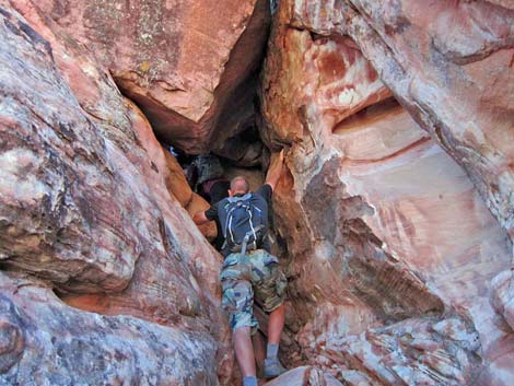
After locating Heart Rock, leave the trail (Wpt. 04) and climb the hillside to the Heart Rock alcove (Wpt. 05). Heart Rock is a fun place for couples to get their photo taken, but remember it takes 3rd-class scrambling to get there. From Heart Rock, the route climbs through the "Tunnel of Love." From Heart Rock, slide into the gully on the right (west) edge of Heart Rock. Climb the gully, staying to the left -- hard against Heart Rock. The route tunnels under a massive boulder, passing through the Tunnel of Love, to a ledge with a nice view. Reported by Nick 3/31/2016: Before there were helper rocks to climb above the ledge. With the helper rock it was Class 3 with mild exposure ... now it is considerably more difficult and exposed. Continuing up the same crack system, the route climbs to the Spiral Staircase. Climb the crack to a headwall, step left and up onto a ledge, then turn back, step across the crack to the other side, and continue up the crack system. |
 Close-up: first view of Slab Rift (view SW) |
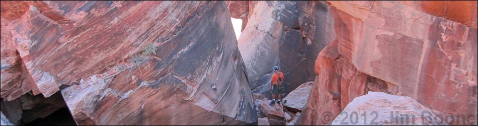
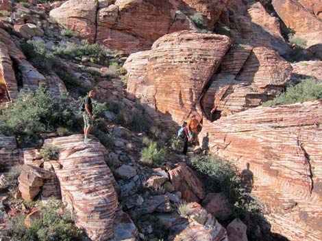
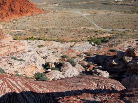
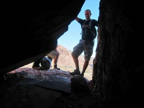
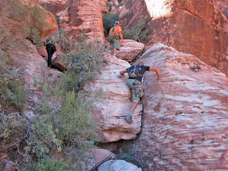
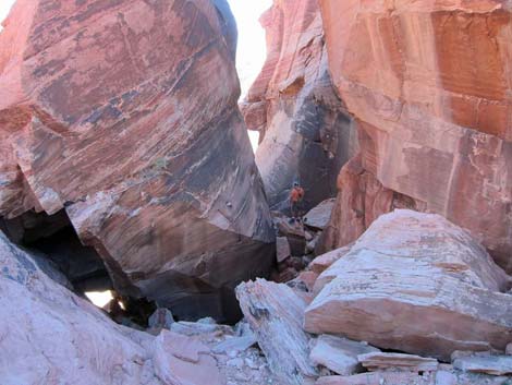
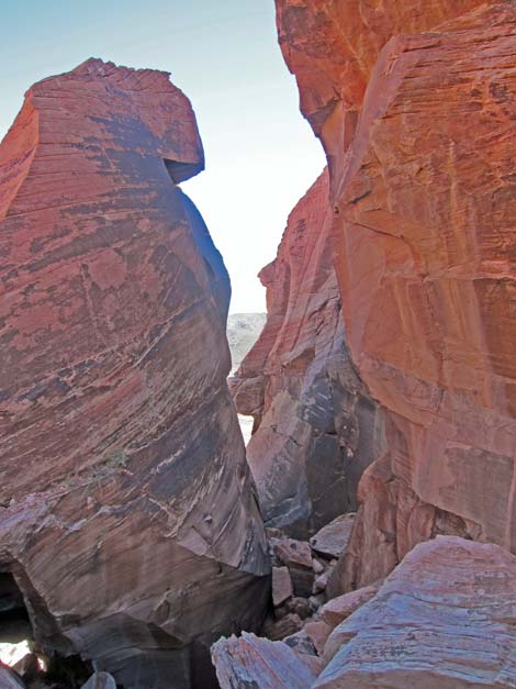
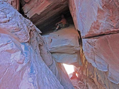
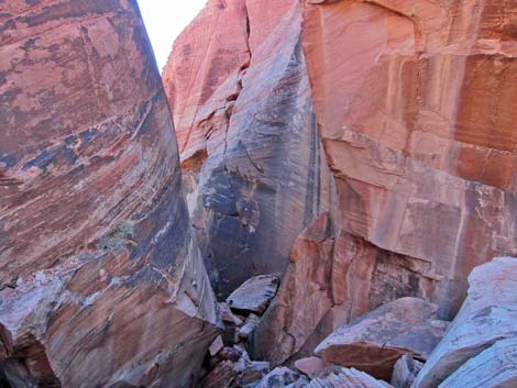
The route ascends what is now a broad gully choked with boulders and shrub live oak to the crest of the Calico Hills, at which point, hikers can turn around and look back down into Slab Rift. The geology is quite spectacular, and photos do not do it justice. Hiking down into the rift, the right side runs out to a shady ledge with a grand view to the northeast. The left fork leads to a hole called the Kitchen Window, a small ledge with a grand view, and above the Kitchen Window is the Attic. When finished inside Slab Rift, hikers can return to the crest and walk south onto the obvious knob some 100-ft distant. This is a nice, sunny place with a view out over Calico I Trailhead to the Red Rock Cliffs. Return to the trailhead by following your footprints in the sandstone, or find any of dozens of other routes down, but be careful as it is easy to get into 4th-class situations. |
 Hikers on route |
 Overview of Heart Rock and the flat-faced boulder |
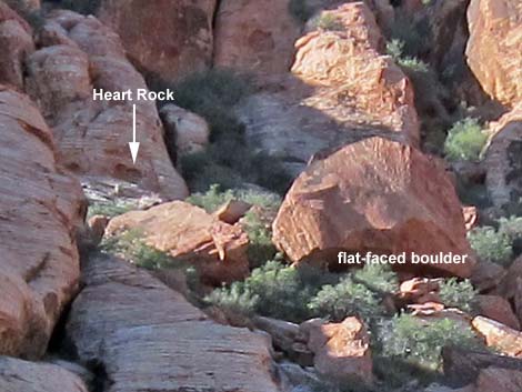 Close-up: Heart Rock and the flat-faced boulder |
 Looking up at Slab Rift (Heart Rock is to the right) |
 Hikers on route |
 Approaching Heart Rock |
 Heart Rock |
 Calico Basin (view N from just below Heart Rock) |
 Heart Rock and the Tunnel of Love |
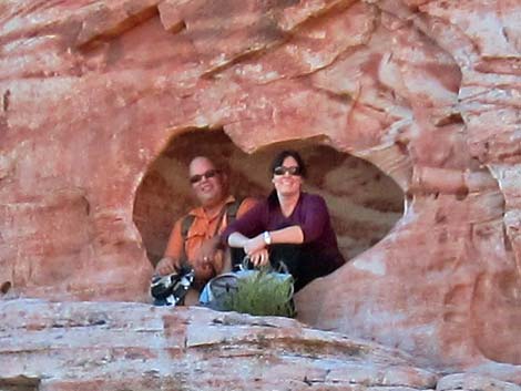 Just friends |
 Heart Rock and the Tunnel of Love |
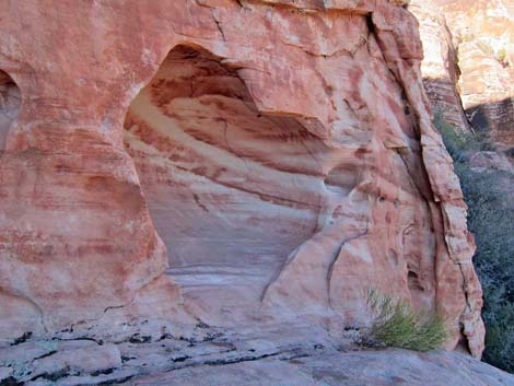 Heart Rock alcove |
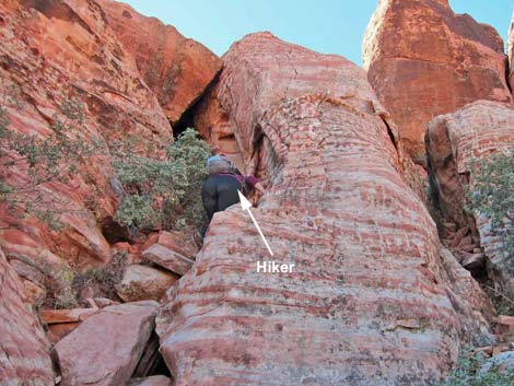 Hiker in Tunnel of Love Crack |
 Hiker entering Tunnel of Love, proper |
 Hiker on ledge past Tunnel of Love |
 All alone in the Tunnel of Love |
 Gully above Tunnel of Love (something has changed here) |
 Stepping across the Spiral Staircase |
 Above Spiral Staircase nearing the crest |
 Slab Rift (view NE from above) |
 Hiker inside Slab Rift (view NE from above) |
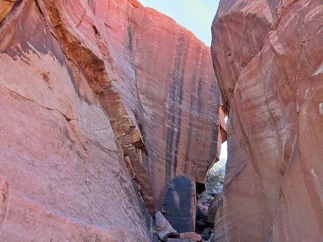 Inside Slab Rift (view SW from below) |
 Inside Slab Rift (view NE from above) |
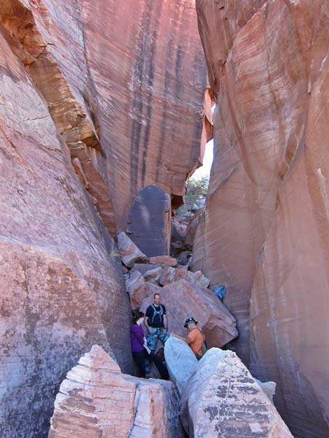 Hikers inside Slab Rift (view SW from below) |
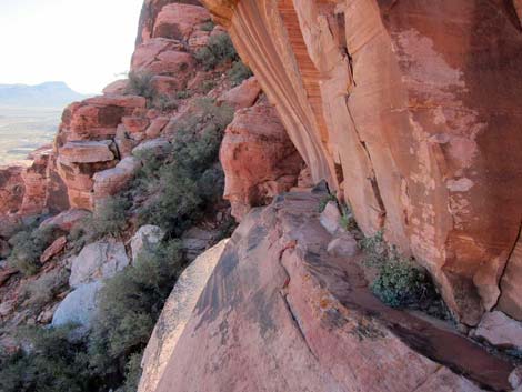 Lunch Ledge (view E) |
 Lunch Ledge (view W) |
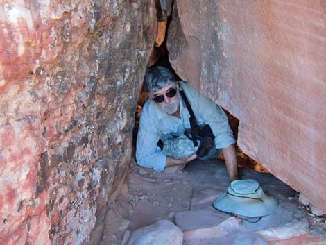
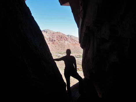 Kitchen Window (view NE) |
 Hiker in Attic above Kitchen Window (view NE) |
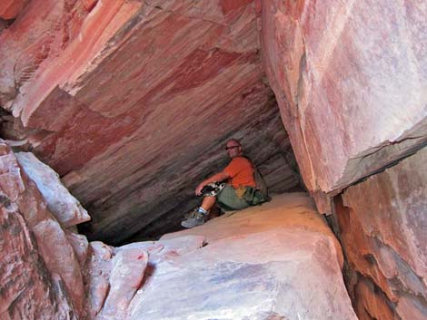 Hiker in the Attic (note typical sloping attic roof; view NE) |
 Slab Rift (view NE from above) |
 Calico I overlook (sunny lunch ledge; view W) |
 Hikers departing Calico I overlook (view N towards Slab Rift) |
Table 2. Hiking Coordinates and Distances based on GPS Data (NAD27; UTM Zone 11S). Download Hiking GPS Waypoints (*.gpx) file.
| Wpt. | Location | UTM Easting | UTM Northing | Elevation (ft) | Point-to-Point Distance (mi) | Cumulative Distance (mi) | Verified |
|---|---|---|---|---|---|---|---|
| 01 | Trailhead | 642323 | 4001239 | 3,513 | 0.00 | 0.00 | GPS |
| 02 | Trail Junction | 642083 | 4001355 | 3,656 | 0.21 | 0.21 | GPS |
| 03 | Cannibal Rock | 641984 | 4001423 | 3,691 | 0.08 | 0.29 | GPS |
| 04 | Depart Use-Trail | 641766 | 4001523 | 3,706 | 0.19 | 0.48 | GPS |
| 05 | Heart Rock | 641697 | 4001405 | 3,906 | 0.18 | 0.66 | GPS |
| 06 | Crest of Calico Hills (Slab Rift) | 641665 | 4001309 | 4,148 | 0.12 | 0.78 | GPS |
| 07 | Calico I Overlook | 641666 | 4001280 | 4,181 | 0.02 | 0.80 | GPS |
| 01 | Trailhead | 642323 | 4001239 | 3,513 | 0.80 | 1.60 | GPS |
Happy Hiking! All distances, elevations, and other facts are approximate.
![]() ; Last updated 240330
; Last updated 240330
| Hiking Around Red Rocks | Hiking Around Las Vegas | Glossary | Copyright, Conditions, Disclaimer | Home |