Hiking Around Las Vegas, Zion National Park
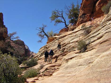 Start of trail: stone stairs and handrails (view W) |
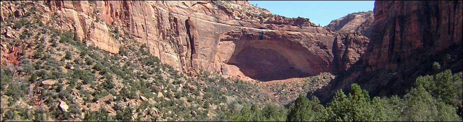
Overview This short, but moderately strenuous trail runs along ledges and over rocks for 0.45 miles to an overlook atop the Great Arch with grand views down Pine Creek Canyon and across lower Zion Canyon to the Streaked Wall and other named mountain peaks. The more-exposed sections of trail are guarded by fencing or handrails, providing the opportunity to safely stand on the edge and look down into the Pine Creek narrows. The view from the overlook is breathtaking, especially the view straight down. Link to map. |
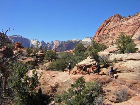
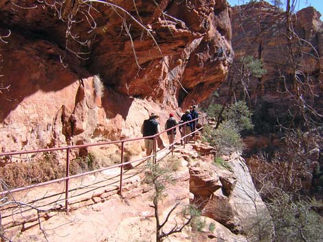 Hiking along the cliffs (view E) |
Watch Out Other than the standard warnings about hiking in the desert, ...this is a safe trail, but there are many places, including at the end, where a false step could be your last. Railings and fencing protect much of the trail, but watch the kids carefully. Other than at the grotto, there is little shade on this trail. Be careful walking across the highway. While hiking, please respect the land and the other people out there, and try to Leave No Trace of your passage. Also, even though this hike is short, be sure to bring what you need of the 10 Essentials. |
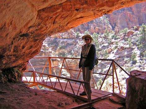 The bridge (view S from inside the grotto) |
Getting to the Trailhead
This hike is located in Zion National Park, about 3 hours northwest of Las Vegas. From town, drive out to Zion National Park. From the Visitor Center (Table 1, Site 863), drive north on Highway 9 for about 1.3 miles to Zion Canyon Road (Site 864). Do not turn left into Zion Canyon, proper; rather, continue straight (east) on Highway 9 (Zion-Mt. Carmel Highway) for another 4.5 miles towards the town of Mt. Carmel. The road switchbacks up the steep hillside and passes the cliffs in a 1.1-mile-long tunnel. The trailhead parking area is on the right (south) side of the road, immediately past (east of) the tunnel. Additional parking can be found along the road just past the parking lot. Park here; this is the trailhead. As you are driving up the switchbacks, notice the Great Arch at the head of the canyon; the trail goes out to the edge of the cliffs atop the arch! |
 Trail on slickrock approaching the overlook (view W) |
The Hike From the parking area, carefully walk across the highway to the ranger booth on the edge of the road, which is at the trailhead. The sight distance on the highway is limited, and drivers coming out of the dark tunnel might have trouble seeing you in the bright light of day. From the trailhead (Table 2, Waypoint 1), the trail begins by climbing the hillside on stone stairs that were blasted out of the cliff. The stairs lead to fairly level ledge system that is followed most of the way out to the overlook. This section of trail runs along cliffs overlooking Pine Creek and is guarded by handrails and chain-link fences. The ledge runs west and ends about a third of the way out to the point, but the trail continues along the cliff and around a corner on a narrow footbridge. The bridge is short, but airy, and leads into a large, cool overhanging grotto with Maidenhair Ferns along the moist back wall (Wpt. 2). |
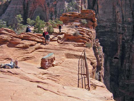 Overlook; notice the one bit of railing (view S) |
After the grotto, the railing and fences end, but there is one more short section of exposed trail just beyond the grotto. After that, the trail runs west and over a low ridge with Two-needle Pinyon Pine and Shrub Live Oak (Wpt. 3). The trail continues west, working over and around rocks along the rocky hillside until reaching the overlook at the edge of the cliffs (Wpt. 4). The views from the overlook are spectacular. A sign at the overlook shows the names of the peaks to the west across the Zion Canyon. Also of note are the air-holes for the Zion-Mt. Carmel Tunnel in the cliff where you can watch cars as they go by inside the tunnel. Below the tunnel, you can watch cars snaking their way along the highway. If you dare, carefully stretch over the railing to see that indeed, you are directly above the Great Arch. Be sure to watch for Desert Spiny Lizards along the trail. |
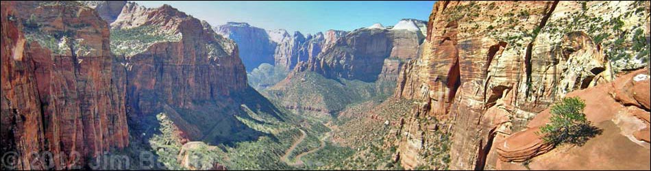
View down Pine Creek Canyon from the overlook (view W)
Table 1. Highway Coordinates based on GPS data (NAD27; UTM Zone 12S). Note: These are UTM-Zone-12 coordinates.
Download Highway GPS Waypoints (*.gpx) file.
| Site | Location | Latitude (°N) | Longitude (°W) | UTM Easting |
UTM Northing |
Elevation (ft) | Verified |
|---|---|---|---|---|---|---|---|
| 0863 | Zion Visitor Center | 37.2000 | 112.9865 | 323702 | 4118706 | 3,940 | Yes |
| 0864 | Highway 9 at Zion Canyon Road | 37.2176 | 112.9736 | 324881 | 4120630 | 4,048 | Yes |
| 0916 | Canyon Overlook Trailhead | 37.2133 | 112.9397 | 327882 | 4120097 | 5,110 | Yes |
Table 2. Hiking Coordinates based on GPS data (NAD27; UTM Zone 12S). Note: These are UTM-Zone-12 coordinates.
Download Hiking GPS Waypoints (*.gpx) file.
| Wpt. | Location | Min | Cum Min | Easting | Northing | Elevation (ft) | Point-to-Point Distance (mi) | Cumulative Distance (mi) |
|---|---|---|---|---|---|---|---|---|
| 01 | Trailhead | 0:00 | 0:00 | 327873 | 4120114 | 5,032 | 0.00 | 0.00 |
| 02 | Grotto | 0:08 | 0:08 | 327687 | 4120140 | 5,216 | 0.17 | 0.17 |
| 03 | Ridge | 0:08 | 0:16 | 327560 | 4120024 | 5,242 | 0.15 | 0.32 |
| 04 | Overlook | 0:09 | 0:23 | 327388 | 4120101 | 5,275 | 0.13 | 0.45 |
Happy Hiking! All distances, elevations, and other facts are approximate.
![]() ; Last updated 240330
; Last updated 240330
| Hiking Around Zion National Park | Hiking Around Las Vegas | Glossary | Copyright, Conditions, Disclaimer | Home |