Birding Around Las Vegas, Outside the Las Vegas Valley

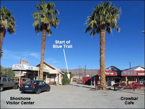
 Shoshone Visitor Center and Crowbar Cafe (view E) |
Description Shoshone is a small town with a bit of water and green amid a very arid piece of desert. This isn't a birding destination, but it is a nice place for traveling birders to stop for the night and do some evening and morning birding. There are five birding trails in town. The Blue Trail starts from downtown and heads east into mesquite and brush thickets down along the Amargosa River. The trail makes a modified figure-8 loop (0.94 miles) out into the saltbrush and mesquite to the edge of the Amargosa River. Link to trail map. |
 Birder between the Visitor Center and the Crowbar Cafe (view E) |
Watch Out Other than the standard warnings about hiking in the desert, ...this hike is pretty safe when the weather is cool. If the weather is hot, this area can be unbelievably hot, so bring some water. Most of the trail is covered with chipped wood (local trees and shrubs), so it can be uneven, making sensible shoes a good idea. The trail cuts through mesquite thickets where birders with big hats need to pay attention to low-hanging branches. While hiking, please respect the land and the other people out there, and please try to Leave No Trace of your passage. This walk is so short that you don't need to bring the 10 Essentials. Getting to the Trailhead The Blue Trail Trailhead is located in downtown Shoshone, between the Visitor Center and Crowbar Cafe. The first blue trail marker is along the walkway between the two buildings. |
 Blue Trail runs into the desert (view E) |
The Blue Trail From the trailhead (Table 1, Waypoint Blue-01), the trail runs east between two buildings. The restrooms for the Crowbar Cafe are behind the main building, so use 'em if you need 'um. Bending a bit to the right and then to the left, the trail starts into the desert following a rock-lined trail (Wpt. Blue-02). Look carefully and notice the first blue trail marker out in the brush. The trail runs east about 50 yards, then bends left and heads north through low shrubs for most of another 100 yards. At this point, the trail turns right to head east into deep saltbrush thickets and mesquite hammocks. Winding about, but generally heading east, the trail runs out to a trail junction (Wpt. Blue-03). This is the start of the first loop. Staying to the left, the trail cuts through mesquite thickets to another trail junction (Wpt. Blue-04). To the left, a spur-trail runs out to the second loop. |
 |
Turning left onto the spur-trail, the trail runs through mesquite thickets to a T-intersection (Wpt. Blue-05). This is the start of the second loop. Staying right, the trail runs out and curves to the left. Towards the end of the loop, birders climb through the middle of a mesquite thicket: good for getting an inside view while birding, but don't plan to get a wheel-chair or child's stroller through here. Continuing, the trail exits the thicket curving left, eventually returning to the T-intersection (Wpt. Blue-05). |
 Birder passing map on trail marker (view E) |
Turning right onto the spur-trail, the trail returns the 100 yards to the main loop (Wpt. Blue-04). Turning left to continue around the first loop, the trail runs out along the Amargosa River and arrives at another trail junction (Wpt. Blue-06). Here, the Blue Trail continues straight, but the Aqua Trail turns left to cross the "river." The Aqua Trail runs east, then turns north to connect with the Red Trail, about 1/2 miles away. Continuing on the Blue Trail, the trail curves to the right where a low-hanging branch waits for birders with big sun hats - don't let it catch you off guard. The trail continues curving to the right, eventually returning to the start of the main loop (Wpt. Blue-03). Turning left, birders begin the hike back to the trailhead (Wpt. Blue-01). |
 Trail turns west at trail marker (view E) |
 Birder on trail (view E) |
 Trail and trail marker (view E) |
 Birders aren't the only ones using the trail (hint: roadrunner tracks) |
 |
 |
 Birder on trail (view E) |
 Birder at the first fork (beginning of the first loop; view E) |
 First fork with bench (beginning of the first loop; view E) |
 Birder staying left on the trail (view NE) |
 Birder at next trail junction; left to spur-loop (view NE) |
 Trail junction with bench; left to spur-loop (view NE) |
 Start of the spur-loop (view N) |
 Birder starting the loop on the spur-loop (view NW) |
 Starting into the depths of a mesquite thicket (view NW) |
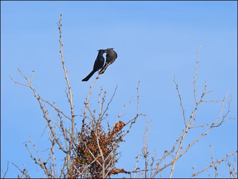
 Phainopepla courting: male feeding female |
 Returning to the first loop (view S) |
 Birder on trail (view SE) |
 Trail junction to Aqua Trail (view S) |
 Trail junction to Aqua Trail (view E) |
 Trail junction sign for Aqua Trail (view E) |
 Birder passing turnoff to Aqua Trail (view S) |
 Side-blotched Lizard along the trail |
 View out over a cattail marsh (view SE) |
 Birders with sore forehead beyond the offending branch (view S) |
 Returning towards the trailhead (view W) |
 Returning to the trailhead (view W) |
 Keep an eye out for other wildlife (e.g., coyotes) |
Table 1. Hiking Coordinates and Distances based on GPS data (NAD27; UTM Zone 11S). Download Hiking GPS Waypoints (*.gpx) file.
| Wpt. | Location | UTM Easting | UTM Northing | Elevation (ft) | Point-to-Point Distance (mi) | Cumulative Distance (mi) | Verified |
|---|---|---|---|---|---|---|---|
| Blue-01 | Blue Trailhead | 565903 | 3981207 | 1,646 | 0.00 | 0.00 | GPS |
| Blue-02 | Start of Trail | 565961 | 3981190 | 1,641 | 0.04 | 0.04 | GPS |
| Blue-03 | Trail Junction | 566145 | 3981304 | 1,624 | 0.19 | 0.23 | GPS |
| Blue-04 | Trail Junction | 566197 | 3981357 | 1,620 | 0.04 | 0.27 | GPS |
| Blue-05 | Start of Loop | 566143 | 3981413 | 1,616 | 0.06 | 0.33 | GPS |
| Blue-05 | Start of Loop | 566143 | 3981413 | 1,616 | 0.15 | 0.48 | GPS |
| Blue-04 | Trail Junction | 566197 | 3981357 | 1,620 | 0.06 | 0.54 | GPS |
| Blue-06 | Trail Junction | 566250 | 3981349 | 1,604 | 0.03 | 0.57 | GPS |
| Blue-03 | Trail Junction | 566145 | 3981304 | 1,624 | 0.10 | 0.67 | GPS |
| Blue-02 | Start of Trail | 565961 | 3981190 | 1,641 | 0.23 | 0.90 | GPS |
| Blue-01 | Blue Trailhead | 565903 | 3981207 | 1,646 | 0.04 | 0.94 | GPS |
Happy birding! All distances, elevations, and other facts are approximate.
![]() ; Last updated 240323
; Last updated 240323
| Birding Around Las Vegas | Southern Nevada Birds | Guide Service | Copyright, Conditions, Disclaimer | Home |