Hiking Around Las Vegas, Gold Butte National Monument

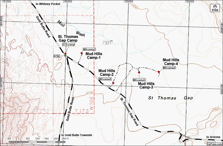
The Mud Hills Campsites are scattered along St. Thomas Gap Road, not far east of Gold Butte Road. The three sites close to the road are suitable for trailers and RVs, but the others are better left to smaller vehicles in dry weather; in wet weather, sites 3 and 4 are likely to become quite muddy and should be avoided. All of these site are on desert flats surrounded by the Mud Hills to the north, Tramp Ridge to the west, and the mountains of Gold Butte Townsite to the south. Views east are blocked by low hills, but otherwise would extend into Arizona. Individually, these sites are quiet and fairly private, but each is small enough to be suitable only for one group at a time. This is a good area to basecamp while hiking or exploring some of the 500 miles of open roads in the Gold Butte region, plus St. Thomas Gap Road provides access to roads in Grand Canyon - Parashant National Monument in Arizona.

Note: Map based on USGS 7.5-minute topo map, which may have red grid lines and various numbers. North is at the top. Grid is UTM NAD27 CONUS. Roads are black (solid = paved; dashed = unpaved; width implies quality). Trails and routes are red (solid = main; dashed = adjacent or alternate). Washes, streams, and lakes are blue (solid = permanent; dashed = intermittent). National Monument Areas (boundaries dash-dot green, fill light green) based on BLM data. Download waypoint coordinates from route description page.
Table 1. Highway Coordinates based on GPS Data (NAD27; UTM Zone 11S). Download Highway GPS Waypoints (gpx) file.
| Site | Location | UTM Easting | UTM Northing | Latitude (N) | Longitude (W) | Elevation (ft) |
|---|---|---|---|---|---|---|
| 0796 | Gold Butte Rd at St Thomas Gap Rd | 757995 | 4033469 | 36.41359 | 114.12277 | 2,427 |
| MH-camp1 | Mud Hills Camp #1 | 758258 | 4033520 | 36.41398 | 114.11983 | 2,425 |
| MH-camp2 | Mud Hills Camp #2 | 758794 | 4033046 | 36.40957 | 114.11401 | 2,461 |
| MH-camp3 | Mud Hills Camp #3 | 759213 | 4033231 | 36.41112 | 114.10929 | 2,441 |
| MH-camp4 | Mud Hills Camp #4 | 759534 | 4033250 | 36.41121 | 114.10571 | 2,434 |
| STG-camp | GB Rd - St. Thomas Gap Campsite | 757995 | 4033499 | 36.41386 | 114.12277 | 2,428 |
Happy Hiking! All distances, elevations, and other facts are approximate.
![]() ; Last updated 241029
; Last updated 241029
| Gold Butte | Camping in Gold Butte | Hiking Around Gold Butte | Glossary | Copyright, Conditions, Disclaimer | Home |