Vegetation Around Las Vegas


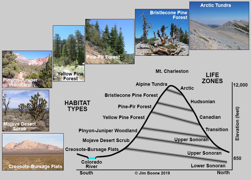
Working in Arizona in the 1890s, C. Hart Merriam (famous ecologist and first director of the U.S. Biological Survey, an organization eventually merged into the U.S. Geological Survey) recognized six major life zones that were influenced by climate (primarily temperature) and expressed as altitudinal zones from low-elevation hot deserts to high-elevation alpine mountains. The zonation results from the fact that as elevation increases, average temperature decreases and average precipitation increases. Merriam found that each elevation zone had a characteristic flora and fauna, and that the pattern repeated across the landscape from one mountain range to another.
Merriam also recognized that in Western North America, an altitudinal change of 1,000 feet was similar to a latitudinal change of 600 miles. Thus, in terms of climate and vegetation, a 600-mile trip north is similar to going up 1,000 feet in elevation. In Arizona, Merriam found that low desert valleys are similar to those in Sonora, Mexico, far to the south, while high-elevation forests are similar to those in the Hudson Bay region, far to the north. Although considered simplistic by modern standards, the fact of vegetation zones adds greatly to organizing our understanding of the diversity of plant and animal life around Las Vegas.
One benefit of this natural zonation pattern in the Las Vegas area is that hikers and travelers can quickly experience several life zones. For example, we can drive from the lowest life zone to near the highest in about two hours, and hikers can traverse several life zones during the course of a day. In other parts of the continent, it might take several days to drive far enough to experience similar differences in vegetation. Each with a characteristic flora and fauna, knowledge of the changing life zones enhances the diversity of experience to our local trips.
Merriam named five of his six life zones for the equivalent latitudinal regions: Sonora (Mexico), Canada, Hudson Bay, and the Arctic. Merriam’s scheme recognizes two basic regions, the southern deserts and northern forests, plus the transition between the two and the high arctic beyond the limits of the northern forests.
| Life Zones | Las Vegas Area Habitat Types | |
|---|---|---|
| 1 | Lower Sonoran (dry deserts) | Creosote-Bursage Flats |
| 2 | Upper Sonoran (brushy scrub) | Mojave Desert Scrub |
| 2 | Upper Sonoran (pinyon-juniper woodland) | Pinyon-Juniper Woodland |
| 3 | Transition (yellow pine forests) | Yellow Pine Forest |
| 4 | Canadian (pine-fir forests) | Pine-Fir Forest |
| 5 | Hudsonian (subalpine forests) | Bristlecone Pine Forest |
| 6 | Arctic (tundra above timberline) | Alpine Tundra |
Although this system of life zones is too simplistic to be used by modern ecologists (everyone knows that the distribution of plants and animals is influenced by more than just temperature and altitude), the pioneering efforts of Merriam are still useful today if we allow the idea of an overall pattern imposed on a local mosaic of weather patterns and plant species. That is, the life zones are real, but the kinds of plants we see in any particular place depend on the climate plus other factors such as aspect, local topography, soil characteristics, fire history, and land-use history. The groups of plants we see in any given place are called vegetation communities or vegetation associations, and they form Habitat Types.
All distances, elevations, and other facts are approximate.
![]() ; Last updated 190818
; Last updated 190818
| Vegetation Around Las Vegas | Glossary | Copyright, Conditions, Disclaimer | Home |