Hiking Around Las Vegas, Red Rock Canyon National Conservation Area

 Red Spring Parking Lot and Picnic Area |
Overview Calico Hills Loop Trail is 6-1/4-mile hike that circumnavigates the Calico Hills. The hike can be considered a series of trail segments that start and stop at any of 6 trailheads (3 along the Scenic Loop Road and 3 in Calico Basin). Most of the loop runs on easy, gently sloping trails, but there are a few steep parts, some off-trail in a wash, and the Ash Canyon segment requires a fair bit of Class-2 and Class 3 scrambling getting down and around boulders and pour-overs. Views from many parts of the loop are grand, with those on the west side of the hills spreading out across all of Red Rock Canyon, and those on the east side looking southeast across Calico Basin and points south. For hikers who have only driven along the Scenic Loop Road, this hike offers an up-close and personal encounter with the Calico Hills that is quite different from the road-side perspective. Link to map. |
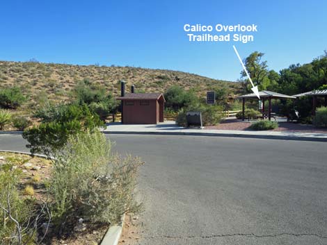 Calico Hills Loop Trail starts at the Calico Overlook Trailhead (view S) |
Watch Out Other than the standard warnings about hiking in the desert, ...this hike is fairly safe and usually not far from a road or trailhead. Ash Canyon requires a bit of Class 3 scrambling, so be extra careful when high enough to fall and get hurt because a rescue from Ash Canyon would be an unpleasant exercise for everyone involved. While hiking, please respect the land and the other people out there, and please try to Leave No Trace of your passage. This is a long hike, so be sure to bring what you need of the 10 Essentials. The Ash Canyon segment of the loop goes into the La Madre Mountain Wilderness Area, so pay particular attention to respecting the land. |
 Calico Overlook Trail departing Red Spring picnic area (view SW) |
Getting to the Trailhead This hike is located in Red Rock Canyon National Conservation Area, about 25-45 minutes from town, depending on the chosen trailhead. As described here, the loop starts at Red Spring Picnic Area in Calico Basin, which is not in the Scenic Loop fee area and therefore provides free access. Other free trailheads in Calico Basin are the Assisi Road and Sandstone Road trailheads. Inside the fee area, Calico I, Calico II, and Sandstone Quarry also serve as trailheads. For Red Spring Picnic Area in Calico Basin, drive out West Charleston Blvd, turn right towards Calico Basin, then drive into the Red Spring Trailhead. Park here; this is the trailhead. The parking area closes at sunset, so park along the road outside the gate if you expect a late return. |
 Red Spring to Calico I (view W) |
The Hike - Red Spring to Calico I From the Calico Hills Overlook Trailhead (Table 1, Waypoint 01), the trail runs south, staying on the dirt trail outside the wooden fence. The route runs south past Red Spring on an old road (Wpt. 02) that climbs steeply to the top of the ridge (Wpt. 03), then just as steeply runs down the other side and hooks right to follow below the red cliffs into an area of enormous sandstone boulders (Wpt. 04). Beyond the boulders, the trail wraps around the south end of the Calico Hills, following above the wash, and eventually crosses the wash (Wpt. 07). Beyond the wash, the trail climbs onto a rocky knob (Wpt. 08). There are several use-trails in this area, but all seem to converge on the knob. The higher trail might be easier. Beyond the rocky knob, the trail climbs towards Calico I Trailhead (Wpt. 09). There are many use-trails in this area, but trails staying low are better unless hikers want to exit the trail system. For photos and details of this segment of the hike, see Red Spring to Calico I. |
 Calico I to Calico II (view N) |
The Hike - Calico I to Calico II From the Calico I trail sign (Wpt. 09), the route continues north on a well-used trail. Shortly, the trail descends towards a wash, and just before the wash, the trail forks (Wpt. 10). All trails in this area lead north towards Calico II, so either fork will do. The right fork, part of the Calico Hills Trail, climbs higher (better views, harder route), and the left fork stays low (easier and shorter). Staying left (Wpt. 10), the trail runs low along the west side of the wash. The trail eventually begins to climb, merges back together with Calico Hills Trail (Wpt. 11), and climbs into the Calico II area, which also has many use-trails. At a signed trail junction (Wpt. 12), the loop trail stays right (more-or-less straight), while the trail up to the Calico II Trailhead turns hard to the left. For photos and details of this segment of the hike, see Calico I to Calico II. |
 Calico II to Sandstone Quarry (view N) |
The Hike - Calico II to Sandstone Quarry Staying right at the Calico II trail junction (Wpt. 12), the loop trail (Calico Hills Trail) climbs gently towards a saddle (Wpt. 13) on a well-used trail. Looking into the distance from the saddle, the trail can be seen dropping towards the wash, passing a set of large boulders, and climbing the hillside towards a saddle. While hiking, look for petroglyphs on the boulders. The Calico Hills Trail runs up the valley and climbs onto the saddle at a point where Sandstone Quarry parking can be seen in the distance. In this area, several use-trails cut up the hillside and others drop into the canyon, but the main trail stays more-or-less on the level before dropping into the south end of the Sandstone Quarry parking area (Wpt. 14). The trail continues north to the far end of the parking lot and the Sandstone Quarry North Trailhead (Wpt. 15). For photos and details of this segment of the hike, see Calico II to Sandstone Quarry. |
 Sandstone Quarry to Ash Canyon (view NE) |
The Hike - Sandstone Quarry to Ash Canyon The Calico Hills Loop Trail exits the north end of Sandstone Quarry parking area. Continuing on the Calico Tanks Trail (Wpt. 15), the trail stays right at the signed Turtlehead Peak Trail junction (Wpt. 18) and starts to wrap around the north end of the Calico Hills. The trail drops back into the wash and runs up into a sandstone canyon. When the narrows open, the Calico Tanks Trail turns out of the main wash (Wpt. 19) to the right (southeast), but the Calico Hills Loop (now just a route) stays left in the wash (northeast). Following the wash, the route continues northeast, passes through red sandstone narrows and then white sandstone narrows (Wpt. 20). Continuing up the wash, the route eventually climbs to a highpoint where the trail crosses off sandstone and onto limestone (Wpt. 21), and begins to wrap around the northeast side of the Calico Hills. Continuing, the trail runs out until dropping towards the top of Ash Canyon (Wpt 23). For photos and details of this segment of the hike, see Sandstone Quarry to Ash Canyon. |
 Ash Canyon (view SE) |
The Hike - Ash Canyon Near the top of Ash Canyon, the use-trail fades out as the route runs onto sandstone. The route passes through a cleft that opens onto an overlook (Wpt. 24) with nice views down Ash Canyon, and beyond the overlook, a well used use-trail runs down the canyon. At a trail junction down the canyon (Wpt. 25), the loop stays right and drops into the canyon bottom. The route provides plenty of scrambling and route finding as it descends through boulders in the canyon. Watch for use-trails on the west side of the canyon. Eventually the canyon ends at Ash Spring (Wpt. 26), and use-trails fan out southward. At a trail junction (Wpt. 27), the loop trail stays right under towering cliffs. The trail climbs a low hill to arrive at an abandoned homesite. Continuing south past the foundation, the trail bends left on what was the driveway and arrives at a trail junction (Wpt. 28). The left trail runs out to the Sandstone Road Trailhead, while the loop trail stays right (uphill) following the Girl Scout Trail. For photos and details of this segment of the hike, see Ash Canyon. |
 Ash Canyon to Red Spring (view SW) |
The Hike - Ash Canyon to Red Spring From the Girl Scout Trail junction (Wpt. 28), a plethora of trails fan out along the hillside. Staying up under the sandstone cliffs, the trail runs south towards Red Spring, which can be seem from this area. Staying more of less under the cliffs, the loop trail bends right into the base of Guardian Canyon (Wpt. 29), then immediately turns back out following the Calico Hills Trail. The trail runs south on slickrock to Cannibal Crag and passes a trail junction to the Assisi Road Trailhead (Wpt. 30). Continuing southward, several trails descend across the hillside into the Red Spring Parking Area (Wpt. 31). For photos and details of this segment of the hike, see Ash Canyon to Red Spring. |
Table 1. Hiking Coordinates Based on GPS Data (NAD27; UTM Zone 11S). Download Hiking GPS Waypoints (*.gpx) file.
| Wpt. | Location | UTM Easting | UTM Northing | Elevation (ft) | Point-to-Point Distance (mi) | Cumulative Distance (mi) |
|---|---|---|---|---|---|---|
| 01 | Red Spring South Trailhead | 642319 | 4001153 | 3,583 | 0.00 | 0.00 |
| 02 | Trail Junction | 642242 | 4000927 | 3,656 | 0.16 | 0.16 |
| 03 | Saddle | 642250 | 4000753 | 3,759 | 0.13 | 0.29 |
| 04 | Boulder Field | 642143 | 4000615 | 3,661 | 0.17 | 0.46 |
| 07 | Wash Crossing | 641831 | 4000741 | 3,651 | 0.24 | 0.70 |
| 08 | Rocky Knob | 641623 | 4000887 | 3,831 | 0.21 | 0.91 |
| 09 | Calico I Trail Junction | 641324 | 4001168 | 3,895 | 0.30 | 1.21 |
| 10 | Trail Junction | 641280 | 4001206 | 3,868 | 0.04 | 1.25 |
| 11 | Trail Junction | 640678 | 4001845 | 3,968 | 0.60 | 1.85 |
| 12 | Calico II Trail Junction | 640618 | 4001855 | 3,996 | 0.04 | 1.89 |
| 13 | Saddle | 640609 | 4002022 | 4,060 | 0.13 | 2.02 |
| 14 | Sandstone Quarry South Trailhead | 639525 | 4002803 | 4,308 | 0.97 | 2.99 |
| 15 | Sandstone Quarry North Trailhead | 639468 | 4002876 | 4,367 | 0.07 | 3.06 |
| 16 | Grand Circle Trail Junction | 639474 | 4002987 | 4,305 | 0.07 | 3.13 |
| 17 | Calico Tanks Trail Junction | 639461 | 4003002 | 4,311 | 0.02 | 3.15 |
| 18 | Turtlehead Peak Trail Junction | 639420 | 4003160 | 4,379 | 0.11 | 3.26 |
| 19 | Calico Tanks Canyon | 639632 | 4003349 | 4,405 | 0.20 | 3.46 |
| 20 | Start of White Narrows | 639814 | 4003479 | 4,422 | 0.18 | 3.64 |
| 21 | Highpoint at Keystone Thrust | 639958 | 4003568 | 4,490 | 0.17 | 3.81 |
| 22 | S Fork, Gateway Canyon Trail Junction | 640314 | 4003484 | 4,544 | 0.24 | 4.05 |
| 23 | Trail Junction | 640433 | 4003364 | 4,518 | 0.11 | 4.16 |
| 24 | Overlook | 640520 | 4003275 | 4,481 | 0.09 | 4.25 |
| 25 | Trail Junction | 640632 | 4003146 | 4,360 | 0.13 | 4.38 |
| 26 | Trail Junction near Ash Spring | 641286 | 4002484 | 3,811 | 0.71 | 5.09 |
| 27 | Trail Junction to Sandstone Rd Trailhead | 641581 | 4002347 | 3,773 | 0.21 | 5.30 |
| 28 | Girl Scout Trail Junction | 641693 | 4002230 | 3,767 | 0.12 | 5.42 |
| 29 | Girl Scout--Calico Hills Trail Junction | 641577 | 4001670 | 3,758 | 0.45 | 5.87 |
| 30 | Trail Junction to Assisi Rd Trailhead | 642006 | 4001427 | 3,690 | 0.34 | 6.21 |
| 31 | Red Spring North Trailhead | 642321 | 4001239 | 3,604 | 0.27 | 6.48 |
Happy Hiking! All distances, elevations, and other facts are approximate.
![]() ; Last updated 200408
; Last updated 200408
| Hiking Around Red Rocks | Hiking Around Las Vegas | Glossary | Copyright, Conditions, Disclaimer | Home |