Hiking Around Las Vegas, Other Areas
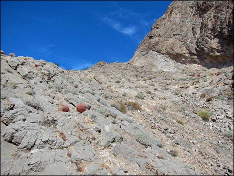
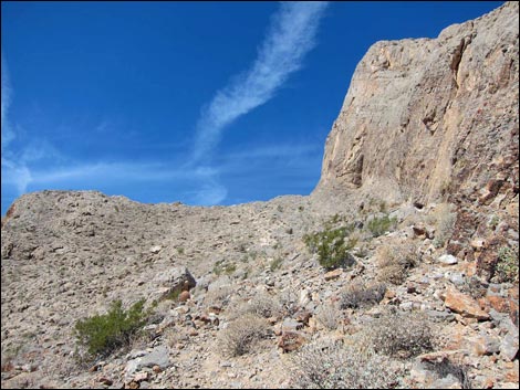 High in the Southeast Gully (view W) |
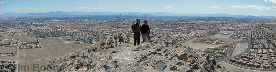
Overview Lone Mountain is a steep, isolated, rocky butte in NW Las Vegas just inside the Interstate-215 Beltway. The summit stands some 600 feet above the surrounding homes, giving great views of the city and the surrounding mountains. There are several routes up Lone Mountain. The Southeast Gully Routes are short, steep, and lead to the South Ridge, south of the summit. The North Ridge, South Ridge, and East Buttress also provide challenging routes. The Southeast Gully primarily is used by rock climbers accessing steep limestone routes on the south-facing walls above the Southeast Gully, but it is also a shorter way to the steep, higher parts of the South Ridge. Link to route map. |
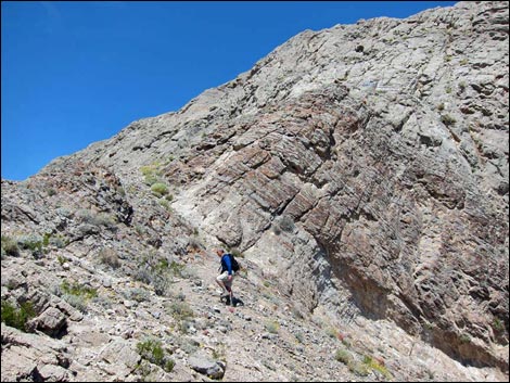
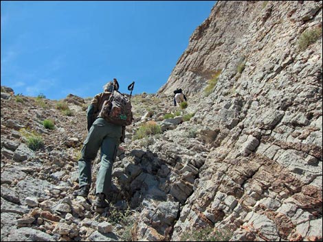 Hikers in the steep Southeast Gully (view W) |
Watch Out Other than the standard warnings about hiking in the desert, ...this is a fairly safe hike, but there are places where you could stumble off the mountain and roll all the way to the bottom. The west face of the summit is nearly vertical, so don't fall off that side. There is a fair bit of loose gravel and rock on this route, so take care and avoid rolling rocks on your hiking party. While hiking, please respect the land and the other people out there, and try to Leave No Trace of your passage. Although this hike is short, be sure to bring what you need of the 10 Essentials. |
 |
Getting to the Trailhead Lone Mountain is located in the northwest part of urban Las Vegas, just inside the Western Beltway (Highway I-215) between Lone Mountain and Alexander roads. From town, drive north on Highway 95 or Highway 215 to the northwest part of town. Continue to the Lone Mountain Discovery Park Trailhead, which is located on the east side of the mountain. |
 Nearing the Crest of the South Ridge (view NW) Nearing the Crest of the South Ridge (view NW) |
The Hike From the Lone Mountain Park Trailhead, old dirt roads run south to several routes providing access the Southeast Gully. Just south of the East Buttress, old roads lead steeply onto the hillside and provide access to climbing routes on the nearby south-facing vertical cliffs. Continuing a bit south along the old road, several routes lead onto the hillside (Wpt. 66; Wpt. 65; Wpt. 64). Starting at any of these points, hikers can climb high onto steep terrain, converging beneath a vertical wall high on the hillside (Wpt. 70). Following along the rock wall, hikers can pick their way among loose rocks to gain the crest of the South Ridge (Wpt. 36). |
 Hiker arriving at the Crest of the South Ridge (view NW) |
On the crest, there is a nice lookout at the south end of the more-or-less level section of the South Ridge (Wpt. 50) that makes a nice place to sit and relax. Hikers might also consider continuing north to the summit following the South Ridge Route, continuing south to the bottom of the mountain following the South Ridge Route, or returning over the same terrain. |
Table 1. Hiking Coordinates and Distances based on GPS Data (NAD27; UTM Zone 11S). Download Hiking GPS Waypoints (*.gpx) file.
| Wpt. | Location | UTM Easting | UTM Northing | Elevation (ft) | Point-to-Point Distance (mi) | Cumulative Distance (mi) | Verified |
|---|---|---|---|---|---|---|---|
| 64 | Trail Forks | 651868 | 4011069 | 2,623 | 0.00 | 0.00 | GPS |
| 65 | Trail Forks | 651868 | 4011286 | 2,628 | 0.00 | 0.00 | GPS |
| 66 | Trail Forks | 651887 | 4011456 | 2,599 | 0.00 | 0.00 | GPS |
| 70 | Trails Merge | 651694 | 4011308 | 2,826 | 0.23 | 0.23 | GPS |
| 32 | Crest of South Ridge | 651557 | 4011264 | 3,071 | 0.11 | 0.34 | GPS |
Happy Hiking! All distances, elevations, and other facts are approximate.
![]() ; Last updated 240330
; Last updated 240330
| Lone Mountain | Hiking Around Las Vegas | Glossary | Copyright, Conditions, Disclaimer | Home |