Backroads Around Las Vegas, Desert National Wildlife Refuge
 Mormon Well Road Conditions Mormon Well Road Conditions |
Mormon Well Road Conditions September 2023. The road is in fairly good condition and passable in a 2WD truck, although 4WD is better for the short sections of bumpy steep hills, and I like 4WD when driving uphill on washboarded roads because my truck has no weight over the rear wheels. There were no deep ruts or large rocks, but overall, the road is very bumpy because parts are like a cobblestone road. The road between Highway 93 and Sawmill Canyon is the worst. Drivers: please send an email with current road conditions. There are plans for a sunlight-activated gate at the fence near Highway 93, but it has not yet been installed. |
 Departing Highway 93: start of Mormon Well Road (view W) |
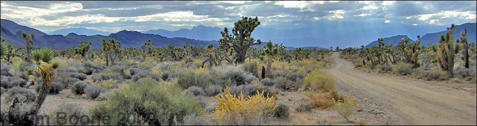
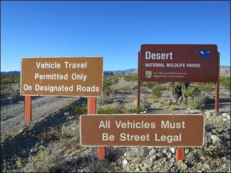
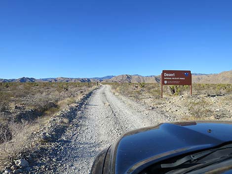
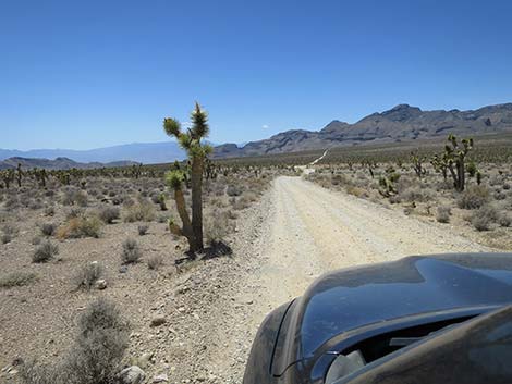
Overview Mormon Well Road is a long, rough, dirt road that runs across Desert National Wildlife Refuge from Highway 93 to Corn Creek. The road runs across the desert and over the mountains through spectacular country, including towering limestone cliffs; broad, flat valleys; and narrow, winding canyons. The road runs through several desert vegetation life zones, starting in the very dry (stunted) Mojave Desert Scrub Zone and climbing to the Yellow Pine (Ponderosa Pine) Zone. The variety of life zones provides different habitats for birds and other wildlife. This road is open to street-legal vehicles only, but usually is passable in a 2WD-HC vehicle. There is no timed-entry gate at the Highway 93 fence. Link to map. |
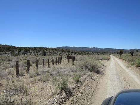
 Approaching Desert National Wildlife Refuge sign (view SW) |
Refuge personnel occasionally maintains the roads, and the road south of Mormon Well usually is in pretty good shape (easy in high-clearance vehicles). North of Mormon Well, however, the road gets pretty rough (almost 4WD). Other than a campground with restrooms, picnic tables, and fire rings, there are no structures or services of any kind, but the road passes near an old corral, listed on the National Register of Historic Places, that was built by Mormon pioneers. Please help preserve Nevada heritage by treading lightly on this fragile land. There are a number of primitive campsites along Mormon Well Road, and there is a campground on the north side of Mormon Pass. Other than that, camping is unrestricted, and drivers can camp anywhere, but be kind to the land and choose an existing campsite; it is illegal to drive off-road to camp. For general information on camping, hiking, regulations, other issues, and the natural history of the Wildlife Refuge, see the Desert National Wildlife Refuge -- Area Overview page. |
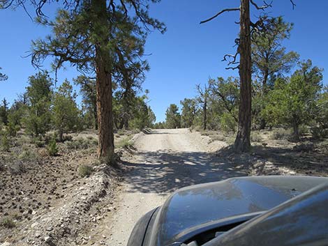
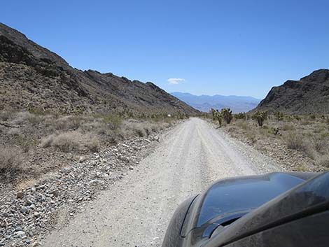
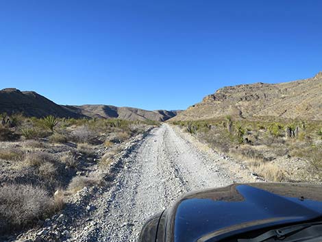 Starting into Elbow Canyon (view SW) |
Watch Out Mormon Well Road is long and rough. A 2WD, high-clearance vehicle is required if the road is dry, and a 4WD vehicle might be needed if the road is wet or washed out. There are no services. If you go out there, take at least 1 gallon of water per person, some food, and expect to be the only people out there. Be prepared to break down and spend a night waiting for help to find you. Your cell phone probably won't work. Although the road is rough, much can be driven at 15 mph in 2WD-HC vehicles, but there are rocky spots and tight turns that seem to sneak up, even at low speeds. In particular, starting into Yucca Forest and out near Sawmill Canyon always seem to be rough. Sawmill Canyon Road is 4WD-only due to deep gravel. The Mormon Well Road is great place to get away from it all, but remember that this is wild and remote country -- you could be the only person out there for a long time. On the other hand, I had a head-on collision out there with a motorcycle. Racing around a blind corner, he thought he was the only vehicle out there. |
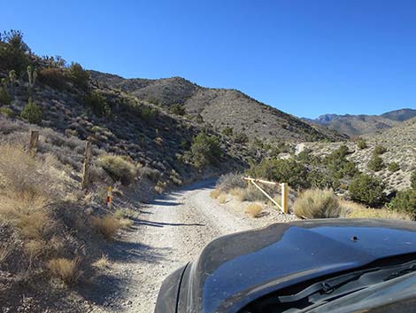 Yellow gate at the entrance to Lower Sawmill Canyon |
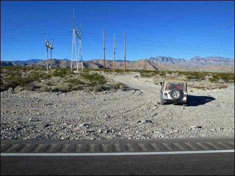
Location Mormon Well Road is located on the Desert National Wildlife Refuge, north of Las Vegas. For driving the road southbound, drive north on I-15 for 21.4 miles to Exit 64 (Highway 93, aka Great Basin Highway). Exit the interstate, turn left, and drive north on Highway 93 towards Alamo for 28.6 miles. Driving north, no signs announce Mormon Well Road (also called Sawmill Canyon Road at this point). Instead, watch the highway mile markers. After mile marker 80, continue north for about 1/2 miles and watch for a power substation on the left and power lines crossing the highway. At the powerlines, turn left onto a gravel road, curve around the power substation, and continue southwest: this is Mormon Well Road. For those who miss the turn, continue north to Highway 168 at Coyote Springs, then turn around and drive back south about 2 miles. |
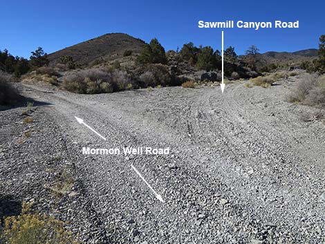 Mormon Well Road at Sawmill Canyon Road (view SW) |
The Road Mormon Well Road, Highway 93 to Sawmill Canyon From Highway 93 (Table 1, Site 0649), Mormon Well Road runs west around the power substation and heads southwest up the bajada towards the mountains. About 200 ft out, the road arrives at the highway right-of-way fence with a gate and signs announcing entry into Desert National Wildlife Refuge. Shortly, at about 0.2 miles out, the road passes an information sign about the refuge with a map. Most of the information deals with being prepared for an adventure in the desert. A variety of regulatory signs are spread out over the next 2 miles, the last of which (2.25 miles out) is a symbol-sign reminding people that ATVs are not allowed on the refuge. This last sign might be a leftover from before the refuge boundary was extended from this area all the way to the highway right-of-way fence. |
 Mormon Well Road in Mormon Canyon (view S) |
In this area, about 2.5 miles out, Mormon Well Road begins to enter Elbow Canyon. Elbow Canyon cuts through a gap in the mountain range ahead, a low ridge that runs parallel to the higher Sheep Range (which is no longer visible in the background). To the south (left), the Las Vegas Range runs south until wrapping around the south end of the Sheep Range (yes, this is a curious geologic story). To the north (right) the Elbow Range runs north for about 10 miles before disappearing into the bajada. Entering Elbow Canyon, the road runs along the base of the Elbow Range, staying out of the loose gravel in the wash. At about 4 miles out, however, the road leaves the high ground to run down across the wash where the gravel can be deep and loose, especially after a flash flood. Across the wash, the road soon bends left (south) to head up what seems to be a side canyon off of Elbow Canyon (Site 1948). In this geologically interesting area, this side canyon is the main Elbow Canyon, and the ridge on the right (west) is actually a giant limestone island surrounded by Elbow Wash. The ridge to the left (east) is the northern tip of the Las Vegas Range). |
 Yellow gate on Mormon Well Rd at Mormon Well parking (view S) |
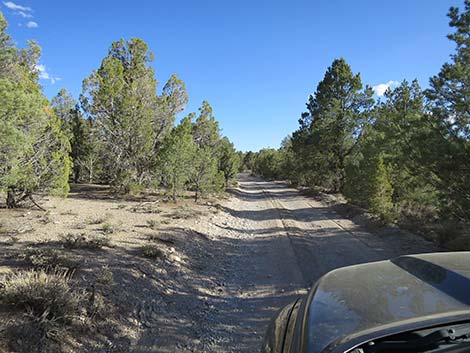
At about 5.3 miles out, Mormon Well Road bends to the right and begins to climb somewhat steeply out of Elbow Canyon, putting this geologically interesting area in the rear-view mirror. From the saddle between the Elbow Canyon Range and the Las Vegas Range, the road actually dips back across Elbow Wash before continuing to climb towards the Sheep Range, which is again visible in the distance. Before too long, the view of the Sheep Range is again blocked by a low limestone ridge in the foreground. This ridge seems to be considered foothills of the Sheep Range, but it is a distinct ridge in this area. At about 8 miles out, Mormon Well Road enters a gap in this ridge and starts up into Lower Sawmill Canyon. The road passes through this gap in the ridge and crosses the open valley between this range and the Sheep Range, proper. |
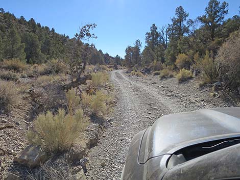
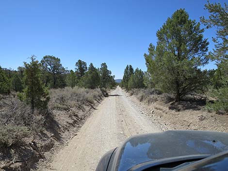
 Mormon Well Road in the Pinyon-Juniper Forest (view S) |
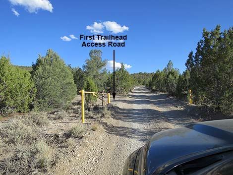
At about 10 miles out, Mormon Well Road arrives at a yellow gate. This gate is used to occasionally close the road between here and Mormon Well when this part of the road is dangerous or impassible. Beyond the yellow gate, the road enters Sawmill Canyon, proper. The road climbs onto the sidehill and runs above the deep, rocky gorge below. Some sections of the road are quite narrow and precipitous. Drivers should watch for oncoming traffic in this area because there are few passing spots, and somebody will have to back up. At about 10.6 miles out, Mormon Well Road drops steeply into Sawmill Wash and then runs upstream through the loose gravel, but only for about 300 yards. When graded, this section should be fine. At about 10.75 miles out, Mormon Well Road, in some of the deepest gravel on the entire road, arrives at a junction with Sawmill Canyon Road (Site 1001). Here, Sawmill Canyon Road forks right and continues west up Sawmill Canyon for about 0.4 miles to a trailhead. The gravel on Sawmill Canyon Road usually is deep and loose, and after getting very stock many years ago, this is where I decided to finally buy a 4WD vehicle. |
 Mormon Well Road approaching Desert Pass Campground (view S) |
Mormon Well Road, Sawmill Canyon to Mormon Well Staying left on Mormon Well Road, the road quickly and steeply climbs out of Sawmill Wash and continues south in an unnamed canyon that might be referred to as "Mormon Canyon" because it runs out past Mormon Well Spring and up to Mormon Pass (aka Desert Pass). Through much of Mormon Canyon, Mormon Well Road runs in the bottom of the wash. In this area, the sand and gravel are rarely bad, but this piece of road is subject to major flash flooding. Vehicles have been lost here in the flooding, and it usually takes heavy equipment to repair the road after a flood. At about 0.2 miles past Sawmill Canyon Road, Mormon Well Road passes a side road (Site 1000), on the right. This road forms a triangle intersection that also runs up to the Sawmill Canyon Trailhead. However, this piece of road usually is worse than the main road up the bottom of Sawmill Canyon. |
 Mormon Well Road approaching the main camp area (view S) |
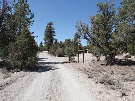
Mormon Well Road continues up Mormon Canyon winding up the wash and climbing onto sidehills when possible. This is a scenic area with lots of Singleleaf Pinyon Pine and Utah Juniper trees, and the last of the Joshua Trees are seen low in this canyon. The mountains on the right (west) are the Sheep Range, proper, while the mountains on the left (east) are the Las Vegas Range. At about 14.3 miles out, Mormon Well Road arrives at another yellow gate. This is the south end of the section of road that occasionally is closed when conditions necessitate. Immediately past the yellow gate, on the left, Mormon Well Road passes the first of three, short spur roads that lead east a few yards to the Mormon Well trailhead parking area (Site 0651) at an old, cement watering trough. The second and third roads are a bit better than the first. From this trailhead, people can walk southeast for about 0.4 miles on an old road to the historical Mormon Corral and Mormon Spring (dry in June 2022). |
 Mormon Well Road approaching Desert Pass (view S) |
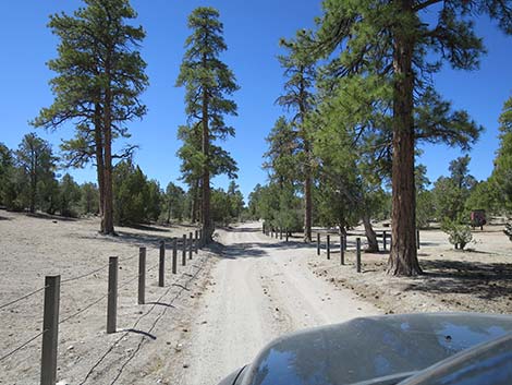
Mormon Well Road, Mormon Well to Desert Pass Continuing south, Mormon Well Road quickly passes two smaller parking areas for the old corral, then bends to the right and crosses to the other side of Mormon Canyon. There is a dusty primitive camping area in the bottom of the canyon here. Mormon Well Road continues south up Mormon Canyon. At this higher elevation, the forest of Singleleaf Pinyon Pine and Utah Juniper trees becomes thicker and denser, and at about 16 miles out, visitors encounter the first of the Ponderosa Pine. In this same area, post-and-cable fencing begins to appear along the side of the road. Shortly, Mormon Well Road arrives at the south edge of Mormon Pass Campground (16.0 miles out). Here, a simple sign announces: "Mormon Pass, Elev. 6,683 feet" (although technically, Mormon Pass is another 0.3 miles up the road). |
 Mormon Well Road descending off Desert Pass (view S) |
Mormon Pass Campground (Site 0648) is spread-out collection of three campsite areas on the right side of the road, plus two isolated campsites on a spur road farther to the right (full-sized trucks are a bit big for both of those sites). Heading south, the road passes the group campsite with a vault toilet, a single campsite, and then the main campsite area. The main campsite area includes another vault toilet, an information sign, one campsite, and two tables designated as day-use picnic tables. Just past this area, a spur-road branches right and leads to the other two small campsites. In all, the campground stretches along Mormon Well Road for about 0.2 miles. Continuing south from the campground for another 0.1 miles, Mormon Well Road passes under the last of the Ponderosa Pine and arrives atop Mormon Pass (16.3 miles out; Site 0647). Here, another simple sign announces "Mormon Pass, Elev. 6,683 feet." There are some overflow campsites on the left, but alas, there is no grand view out over the landscape to the south. |
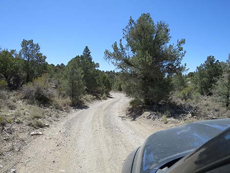 Mormon Well Road sometimes turns tight, blind corners (view S) |
Mormon Well Road, Desert Pass to Peek-A-Boo Canyon Atop Mormon Pass, the mountains on the right (west) are still the Sheep Range, proper, while the mountains on the left (east) still are the Las Vegas Range. South of Mormon Pass, there is very little sand and gravel in the roadway, as the road generally runs on firm ground. When wet, however, there can be some serious mud over the next two miles or so. Farther out, the road becomes quite bumpy, as the road seems to be all cobblestones for long stretches. Descending off Mormon Pass, the road runs generally south through forested areas and broad, open valleys. In places, the road runs straight and open, but in others it winds through tight, forested curves with limited sight lines. Farther out, the conifer trees become sparse and desert plants, including Joshua Trees, start to mixed back in. |
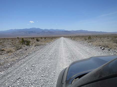
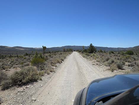 Mormon Well Road traversing high, open country (view S) |
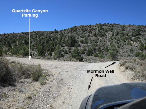
At about 21 miles out, Mormon Well Road passes a service road (Site 1949) on the left, which is marked by fencing and signs indicating no public vehicle access. The service road runs up the valley to the east to an old cattle tank: Searles Reservoir. This road also marks an exit from the Sheep Range mountains and entrance into the headwaters of Peek-a-boo Wash. The road generally runs down the wide, open valley. At about 23 miles out, Mormon Well Road bends hard to the right where a spur road (Site 1046) branches to the left. This short road leads to a parking area for the hike up Quartzite Canyon. Mormon Well Road, Peek-A-Boo Canyon to Pine Nut Road The curve also marks the beginning of the descent through Peek-a-boo Canyon. Peek-a-boo Canyon might be another case of a canyon cutting through a mountain of limestone, but it also might be a gap between two mountain ranges that got smashed together. As with Elbow Canyon, the geology here is complicated. The ridge on the right remains part of the Sheep Range, although this particular ridge is a distinct spur-ridge off of the main Sheep Range, proper. The ridge on the right remains the Las Vegas Range. |
 Mormon Well Road at Searles Reservoir (view S) |
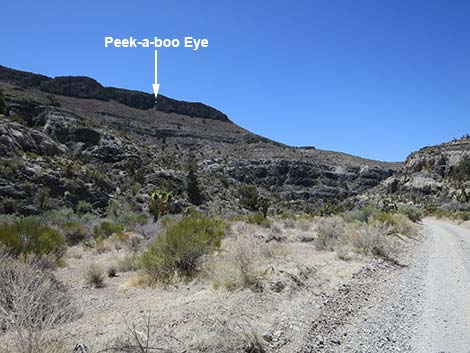
Heading down, the canyon begins to narrow as the ridges on both sides become higher. Eventually, the roadway becomes narrower, and the turns become tighter. This is a good area to drive slowly anticipating oncoming traffic on blind curves. At about 26.2 miles out, Mormon Well Road crosses the wash to the left side of the canyon and views down the canyon open up. It is here that people get the best view of the peek-a-boo hole in the ridge high on the left. Watch carefully and don't blink, as the hole winks out of sight quickly. At about 26.7 miles out, Mormon Well Road is passing through the deepest and most spectacular part of Peek-a-boo Canyon. At this point, parking on the left provides access to a short climb to a cave in the wall on the left. With care, the scramble up to the curve is not particularly dangerous. The cave is large but not particularly deep, and it is a fun place to stop and stretch one's legs. |
 Mormon Well Road at Quartzite Canyon spur road (view S) |
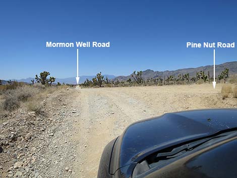
Continuing down the canyon, at about 26.9 miles out, Mormon Well Road passes a Peek-a-boo Canyon sign (look back to read it), bends hard to the left, and begins to exit Peek-a-boo Canyon. At about 27.0 miles out, Mormon Well Road passes entirely out of Peek-a-boo Canyon and enters upon the Yucca Forest. The Yucca Forest is a broad, open, triangular shaped valley full of Joshua Trees (a species of Yucca), Banana Yucca at higher elevations, and Mojave Yucca at lower elevations. The Yucca Forest Valley is tucked between the Sheep Range, proper, on the west side, the Las Vegas Range on the south side, and the Sheep Range, improper, on the east side. Here, the Las Vegas Range runs east-west rather than north-south (think about the geologic forces causing that!). Starting across Yucca Forest Valley, Mormon Well Road crosses several braided washers and shortly arrives at an intersection with Pine Nut Road (27.5 miles out; Site 0424), on the right. Pine Nut Road runs north-northwest for about 6 miles to a small, primitive camp area in the Pinyon-Juniper Forest on the lower flanks of the Sheep Range, proper. The road is bumpy, but not particularly bad unless washed out after flash floods. |
 Mormon Well Road in Peek-A-Boo Canyon (view SW) |
Mormon Well Road, Pine Nut Road to Yucca Gap Continuing southwest, Mormon Well Road runs fairly straight on high ground with views out across Yucca Forest Valley. In places, the road runs along the edge of a cliff overlooking a wash below, and in other places it curves and dips steeply into washes. At about 29.9 miles out, the road passes a traditional camping area on a bluff overlooking the Yucca Forest (Site 1045) with spectacular views to the north across millions of Joshua Trees that seem to carpet the valley. Shortly past the overlook, Mormon Well Road bends sharply right and cuts down a gully to the washes below. After crossing the main wash area, about 30.1 miles out, the road bends left and begin a long, nearly straight runs across the middle of Yucca Forest Valley. Still running more-or-less straight, at about 31.4 miles out, Mormon Well Road passes a Yucca Forest sign (Site 0096); look back to read the text. In another 0.3 miles, at 31.6 miles out, the road finally makes a turn. |
 Mormon Well Road at Pine Nut Road (view W) |
Curving left, Mormon Well Road begins a long series of S-curves as it crosses two deep gullies. The road runs south 0.3 miles to a sharp, downhill hairpin-curve to the right, then runs north about 0.2 miles to a sharp hairpin-curve left, cuts down 0.1 miles to a not-so-sharp hairpin-curve to the right, and finally runs back north about 0.2 miles to a 90-degree curve left, which brings the road back in line with the long, straight traverse across the Yucca Forest. Continuing, Mormon Well Road runs west again for about 0.2 miles to Long Canyon Trailhead (32.7 miles out; Site 0883). The road curves hard to the left, with trailhead parking on the right. The Yucca Peak and Long Canyon hikes start here. The Long Canyon Curve begins a long, southward run for Mormon Well Road as it descends the steep bajada. In this area, the road provides nice views of the towering cliffs and curious caves along the Sheep Range, proper, but rocks and holes in the road require constant attention. |
 Mormon Well Road crossing Yucca Forest Flats (view W) |
At about 32.8 out, not far below Long Canyon Curve, Mormon Well Road makes a sharp curve right and cuts down a gully to cross the last wash. This time, however, the road curves back to the left and continues southwest on high ground for another 2 miles. Getting ever closer to Fossil Ridge, part of the Las Vegas Range, visitors get a great view of layered limestone tipped up on the mountainside. Think of this mountain as a round layer cake with different colors of frosting between different colored layers of cake. Cut out 1/4 of the cake, tilt the point of the cut-cake away and upward, and look at it from the side. Geometrically, this is the same as the layers we see on this limestone mountainside. Mormon Well Road eventually begins curving right to head northwest parallel to Fossil Ridge. The road abruptly curves left (35.4 miles out) to cross the broad wash, which drains all of the Yucca Forest watershed, and then continues westward. Across the wash on higher ground adjacent to Fossil Ridge, the road runs west into another gap through the mountains. As back in Mormon Canyon, the Sheep Range, proper, is on the right, and the Las Vegas Range is on the left. |
 Mormon Well Road passing through Yucca Gap (view W) |
This time the canyon has a proper name: Yucca Gap. It is interesting to note that in the Sheep Range, the limestone ridges are aligned north-south, while in the Las Vegas Range, the limestone ridges are aligned east-west, with only the narrow span of Yucca Gap separating them. This part of the Las Vegas Range is referred to as Fossil Ridge, and for good reason -- there are lots of fossils in the limestone here. A great place to see them is at about 36.3 miles out. Watch for a small gravel parking area on the left just before limestone wall is almost close enough to touch from the driver seat. At the base of the rock wall, about 10 yards back from the road, visitors can see a spectacular collection of snail fossils in the limestone. Note the people have unsuccessfully tried to remove some of the snails; don't repeat their mistake -- it just messes up the place. Mormon Well Road, Yucca Gap to Corn Creek Continuing west, at about 36. 3 miles out, Mormon Well Road passes a small sign on the left announcing "Fossil Ridge;" look back to read the text. |
 Mormon Well Road running straight down the bajada (view W) |
Continuing west, at about 36. 8 miles out, Mormon Well Road exits Yucca Gap onto the vast bajada that forms the west side of the Sheep Range. At about 37.3 miles out, Mormon Well Road reaches a T-intersection with Gass Peak Road. Gass Peak Road, to the left, runs south then east into the Las Vegas Range passing between Fossil Ridge on the left and Gass Peak Ridge on the right. This road leads to several camping areas and hiking trailheads. Mormon Well Road continues west passing a curious block of limestone on the right that harbors quite a cactus garden. The road curves to the right to pass along the west side of this limestone block, then turns back to the left and continues down the bajada. At the curve, there is a large primitive campsite. Before long, Mormon Well Road curves to the right and drops steeply to cross a broad wash. As elsewhere in similar situations, this bit of road can be rather rough because drivers in 2WD vehicles spin their tires and dig holes in the road. At about 38.9 miles out, the road makes a slight curve to the left and begins a long, straight run down the hillside. |
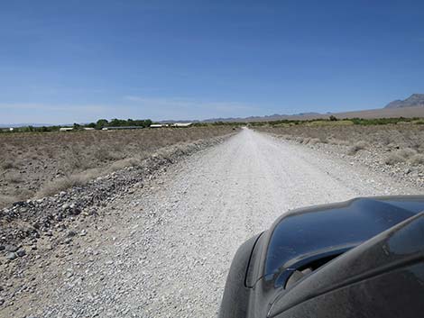 Mormon Well Road approaching Corn Creek Field Station (view N) |
At about 41.0 miles out, the long, straight run is briefly interrupted as the road curve slightly to the left to avoid a spring area. This damp spot on the ground has been entirely taken over by Indian Hemp (Apocynum cannabinum). Despite the name and the appearance of a nice leafy vegetable, all parts of the plant are poisonous and is said to cause cardiac arrest if ingested. Just beyond the spring, the road passes through a third yellow gate. Immediately beyond the gate, a spur road branches right into the old Corn Creek Picnic Area. Shortly ahead, the other side of the triangle intersection also branches right into the picnic area. At about 41.3 miles out, Mormon Well Road curves 90-degrees to the right and runs straight north towards Corn Creek, the buildings of which can be seen ahead in the near distance. Finally, at about 41.7 miles out, Mormon Well Road ends at a three-way intersection. Here, the paved Corn Creek Road branches to the left, while the dirt Alamo Road continues straight. |
Table 1. GPS Coordinates Based on GPS Data (NAD83; UTM Zone 11S). Download Highway GPS Waypoints (*.gpx) file.
| Wpt. | Location | Latitude (N) | Longitude (W) | Elevation (ft) | Point-to-Point Distance (mi) | Cumulative Distance (mi) |
|---|---|---|---|---|---|---|
| 0649 | Hwy 93 at Mormon Well Rd | 36.76753 | 114.94028 | 2,507 | 00.00 | 00.00 |
| 1948 | Mormon Rd at Elbow Canyon | 36.74155 | 115.01245 | 3,526 | 04.57 | 04.57 |
| 1001 | Mormon Rd at Sawmill Cyn Rd | 36.69582 | 115.08862 | 5,510 | 06.19 | 10.76 |
| 1000 | Mormon Rd @ Sawmill Cyn S Rd | 36.69381 | 115.09113 | 5,572 | 00.21 | 10.97 |
| 0651 | Mormon Rd at Mormon Well, N | 36.64725 | 115.09951 | 6,350 | 03.40 | 14.37 |
| 0650 | Mormon Rd at Mormon Well, S | 36.64625 | 115.09942 | 6,350 | 00.07 | 14.44 |
| 0648 | Desert Pass Camp | 36.62445 | 115.11101 | 6,700 | 01.77 | 16.21 |
| 0647 | Mormon Pass | 36.62253 | 115.11110 | 6,700 | 00.13 | 16.34 |
| 1949 | Mormon Rd at Searles Reservoir Rd | 36.55967 | 115.09642 | 6,028 | 04.59 | 20.93 |
| 1046 | Mormon Rd at Old Road Trail | 36.53239 | 115.10627 | 5,822 | 02.05 | 22.98 |
| 0108 | Mormon Rd at Peek-a-boo Cave | 36.50276 | 115.15149 | 5,480 | 03.69 | 26.67 |
| 0424 | Mormon Rd at Pine Nut Rd | 36.50165 | 115.16431 | 5,282 | 00.79 | 27.46 |
| 1045 | Yucca Forest Overlook | 36.47893 | 115.19540 | 4,855 | 02.45 | 29.91 |
| 0096 | Mormon Rd at Yucca Forest | 36.47713 | 115.22068 | 4,830 | 01.46 | 31.37 |
| 0883 | Mormon Rd at Long Canyon TH | 36.47662 | 115.23237 | 4,988 | 01.29 | 32.66 |
| 1950 | Yucca Gap Fossils | 36.44356 | 115.26719 | 3,967 | 03.60 | 36.26 |
| 0884 | Mormon Rd at Gass Peak Rd | 36.43986 | 115.28449 | 3,652 | 01.01 | 37.27 |
| 0731 | Corn Creek Rd@Mormon-Alamo jct | 36.43808 | 115.35654 | 2,814 | 04.41 | 41.68 |
Happy Hiking! All distances, elevations, and other facts are approximate.
![]() ; Last updated 240324
; Last updated 240324
| Backroads | Hiking Around Las Vegas | Glossary | Copyright, Conditions, Disclaimer | Home |