Hiking Around Las Vegas
| Hikes | Points of Interest | Backroads | Backroads | Campsites |
|---|---|---|---|---|
Link to 17 campsites |
Overview of Basin and Range National Monument
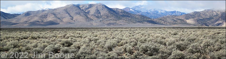
Basin and Range National Monument (map) is a vast area of nearly undisturbed public land in Lincoln and Nye counties that includes grand scenery, ecological value, many cultural and historic sites, and an enormous earth art project called City. Basin and Range has a long history of sheep and cattle ranching in the heart of Nevada and provides habitat for Pronghorn, Pygmy Rabbits, and Dark Kangaroo Mice.
Basin and Range is vast -- over 700,000 acres. Stretching some 50 miles north-south and 45 miles east-west. Much of the area can be seen on a driving tour. The area includes six mountain ranges with peaks climbing to almost 9,000 feet and numerous inter-mountain valleys (basins). Driving from south to north requires traversing about 90 miles of moderate to good dirt roads. The National Monument seems even bigger and more inclusive because it is adjacent to four Wilderness areas, U.S. Forest Service lands, and wild BLM lands.
At present, there are no developed recreational opportunities within Basin and Range National Monument, but visitors are welcome to visit petroglyph sites, camp, hike, ride horses, tour the dirt roads on bikes and off-road vehicles, stargaze, watch birds, hunt, rock climb, and just spend time in quiet solitude.
There are three nice brochures about the area produced by the Nevada Rock Art Foundation, one for the Mount Irish area, one for the White River Narrows area, and one for Shooting Gallery area.
Getting to Basin and Range National Monument
Basin and Range National Monument is located some 110-180 miles north of Las Vegas and straddles the border of Lincoln and Nye Counties (google map). From Las Vegas, drive north on Interstate-15 for 21 miles to Highway 93. Turn left onto Great Basin Highway (Hwy 93) and top off the gas tank if necessary. Drive north past the towns of Alamo (95 miles from Las Vegas) and Ash Springs (102 miles) to the intersection of Highway 93 and Highway 318 (107 miles). Gasoline is available in Alamo, Ash Springs, Lund, and Rachel.
Turn left onto Highway 318 and drive west for 0.7 miles to Crystal Spring, which is marked by a stand of tall cottonwood trees. The road forks here; stay right on Highway 318. The other fork, Highway 375 (the Extraterrestrial Highway), continues west towards the town of Rachel and provides access to southern and southwestern portions of Basin and Range National Monument. From Crystal Spring, the main access to the National Monument is to the right, up Highway 318.
Visitors might consider this driving tour of Basin and Range.
Happy hiking! All distances, elevations, and other facts are approximate.
![]() ; Last updated 241127
; Last updated 241127
| Rock Art Around Las Vegas | Hiking Around Las Vegas | Glossary | Copyright, Conditions, Disclaimer | Home |